

Hillsborough promontory juts into the sea between Ilfracombe harbour and Hele Bay. To the north and west are precipitous cliffs, with steep slopes to the east. To the south, the neck of the headland is about 300 metres wide and slopes down to the mainland. Across the neck are what appear to be three massive ramparts, enclosing the top of the headland, an area of about 25 acres.
Hillsborough is highly defensible, an excellent viewpoint to watch the Bristol Channel and is accessible from the sea; on either side are beaches (Rapparee and Hele) suitable for landing shallow-bottomed boats. Perhaps just as important, Hillsborough is visually very impressive, especially when seen from the approach along the Ilfracombe ridgeway. It is said to be one of the few places in England where, at certain times of the year, the sun can be seen rising from and setting into the sea, By local tradition it was a burial place of ancient Chiefs and this seems to be suggested by its name, which comes from Hele's-barrow (or burrow, which has the same meaning; not actually a burial place but a hill or hillock) (1).
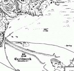
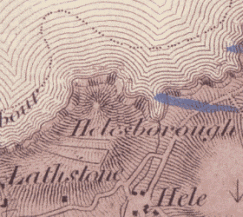
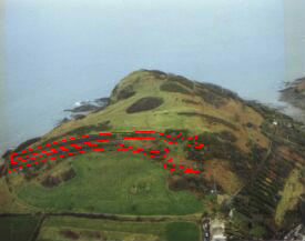
The first Ordnance Survey map of 1809 (above left) shows what appears to be three ramparts running across the southern slope of Hillsborough. By local tradition they were thought to be a Roman encampment, but in 1879 Mrs Slade-King wrote "there are some doubtful remains of British earthworks on the land side of Hillsborough, but no evidence exists of any Roman military or domestic occupation". Ten years later, when the Ordnance Survey produced the first 1:2,500 scale map of Hele, the importance of the earthworks were evidently recognised, and they were surveyed in some detail (right). This is the only survey of the earthworks and it clearly shows two parallel ramparts, each with an inturned entrance, close together at the west but diverging at the east, where they have been disturbed by later limestone quarrying. The survey identified the third upper 'rampart' as a collapsed post-medieval boundary wall. The map shows a spring inside the ramparts - the tumulus marked at the summit of the hill is now thought to be natural. The two ramparts are shown outlined in red on this aerial photograph (below left) (2).
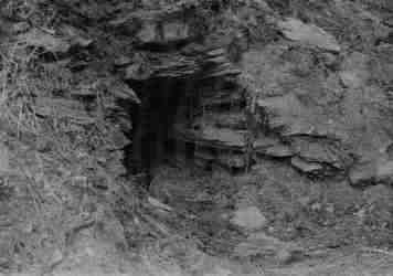
Workmen digging a trench on Hillsborough in 1937, to limit the spread of a gorse fire, found a small chamber in the side of the upper rampart. Unfortunately it was filled in before it could be properly investigated. The founding curator of Ilfracombe Museum, Mervyn Palmer, who took this photograph (below right), thought it may be a burial cist, in which case it is very important; if it dates from the Iron Age then it is the only such burial known in North Devon; but if it dates from the Bronze Age, then Hillsborough was occupied earlier than is presently thought (3).
 In 1967Charles Whybrow published a study of several multivallate
hillforts (i.e. those with more than one rampart) in North Devon. He noted the
similarity between Hillsborough and other promontory forts in Cornwall;
especially Embury Beacon near Hartland. He pointed out that the ramparts
at Hillsborough were made by pulling material down from above; that the complex inturned
entrances suggested a relatively late date, and that the ramparts diverge at the
eastern end to form an enclosure that is overlooked by a natural
mound. He did not guess the purpose of this enclosure, but it may have been designed
to contain an enemy who had breached the lower rampart (4).
In 1967Charles Whybrow published a study of several multivallate
hillforts (i.e. those with more than one rampart) in North Devon. He noted the
similarity between Hillsborough and other promontory forts in Cornwall;
especially Embury Beacon near Hartland. He pointed out that the ramparts
at Hillsborough were made by pulling material down from above; that the complex inturned
entrances suggested a relatively late date, and that the ramparts diverge at the
eastern end to form an enclosure that is overlooked by a natural
mound. He did not guess the purpose of this enclosure, but it may have been designed
to contain an enemy who had breached the lower rampart (4).
In 1970 Whybrow further proposed that Hillsborough was built by the Veneti, a warlike maritime tribe, thought to have fled Brittany c50 BC when Gaul was conquered by Julius Ceaser. It may have been abandoned before the Roman invasion c50 AD, as indicated by excavations in the late 1930's at Milber Down. However, in the early 1970's, a limited excavation at Embury Beacon, showed that the hillfort there had an earlier occupation, and in 1978 John Longhurst, then curator of Ilfracombe Museum, suggested that Hillsborough was similarly occupied between c300 BC and c50 AD (5).
Many hillforts are thought to have had a wooden palisade on top of the ramparts and large wooden entrance gates. Hillsborough, with two sets of palisades and gates, would have been an impressive sight indeed! There was probably some form of defensive boundary on the eastern side; perhaps a rampart, as suggested by the 1809 Ordnance Survey map; perhaps another palisade. The hillfort may have been occupied, possibly by the local tribal leader and his family; the most likely place is a level area just inside the inner rampart. This may have contained rectangular buildings similar to those found at Embury Beacon (6).
Hillsborough hillfort certainly seems to have been built to be defended and in times of trouble it could have provided refuge for many people and their animals. But it couldn’t have permanently supported all the people necessary for its construction and defence; there must have been several settlements nearby belonging to the same tribe. Perhaps there was one such settlement on Larkstone meadow, where traces of hut-circles are said to have been seen in the past. Another possible site is the top of small hill just inland of the Corn Mill, which has a spring nearby.
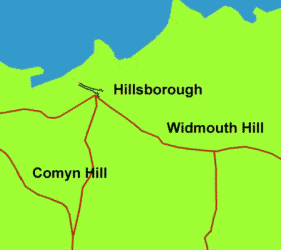 It is likely that Hillsborough was on a coastal ridgeway (left)
which joined the ends of the Ilfracombe, Widmouth and Berrynarbor ridgeways and
continued to Combe Martin, passing the hillfort at Newberry. Although both
hillforts may not have been occupied at the same time, it is tempting to imagine
that they could have signalled each
other via lookouts on the top of Widmouth Hill and Haggington Hill (7).
It is likely that Hillsborough was on a coastal ridgeway (left)
which joined the ends of the Ilfracombe, Widmouth and Berrynarbor ridgeways and
continued to Combe Martin, passing the hillfort at Newberry. Although both
hillforts may not have been occupied at the same time, it is tempting to imagine
that they could have signalled each
other via lookouts on the top of Widmouth Hill and Haggington Hill (7).
In 1962 and again in 1972 it was proposed to run a cable-car to the top of Hillsborough. Any such plans were permanently scrapped when the hill-fort was listed as a Scheduled Ancient Monument in 1978. The field investigator called it a fine promontory fort but added a note that he thought the alleged cist or fogou was an animal’s burrow. In the early 1980's a ski-run was proposed on the southern slopes, just below the ramparts; John Longhurst wrote a series of letters to determine the Scheduled boundary, which was unclear, and as a result it was established that the boundary extended south of the ramparts and the proposed ski-run was dropped (8).
When Hillsborough became a Nature Reserve in 1993 it was recommended that it be grazed, as it had been in the past, to prevent further damage to the earthworks by shrubs and rabbits, but this was strongly resisted by local people who did not want to see fences erected. In 1996 Aileen Fox wrote that "regrettably the hillfort defences are badly overgrown". In 2000 Tanya Walls noted a possible previously unrecorded earthwork at Beacon Point and again recommended that the hillfort be grazed. She suggested that a proper surface and geophysical survey be carried out, but referred to an earlier visit by English Heritage which concluded that the site was already too overgrown to conduct a proper survey. It is a great pity that one of Ilfracombe's most important historical treasures is in such neglect (11).
(1) Oral Tradition
"Hillsborough derives its name from Hele’s Burrow. This eminence of approx. 500 ft. shields Ilfracombe from east winds. Facing the sea it consists of rocky cliffs crowned by grassy slopes. ...From the top in June the sunrise as well as the sunset can be seen over the sea." (Wood 1957? p 11)
"Hillsborough is one of the few places in England from which the sun can be seen as if it rises and sets in the sea" (Wilson 1976 p 65)
"IDENTIFIED AS FORMER FORT - An escarpment on Ilfracombe's 600-feet-high Hillsborough has been scheduled by the Ministry of Works as an ancient monument.... There is a belief that the escarpment, which dates back to pre-Roman days, is the burial ground of ancient chieftains." (Unidentified newspaper cutting, Hillsborough box, Ilfracombe Museum. Hillsborough was Scheduled in 1978)
26 May 1982 - Letter from J Longhurst (then curator of Ilfracombe Museum) to H Quinell "We can build up a fanciful picture of the people landing at Larkstone (a corruption of Lasting) Cove, and having their settlement in the field next to the cove by the stream, and at the foot of the hill where there are reputed hut circles to be seen when the light is right. One man states that the circles were always visible when the hay was cut when the site was still part of Brimlands Farm, and at last full moon another man stated that he had seen them clearly - alas no photograph. We do have in the Museum, three flints found on, or at the foot of Hillsborough, and a photograph of a reputed Bronze Age Cist or burrow discovered some 40 years ago, on the west side of the hill. There is a probable site of another, on the Hele (east) side. Until recently, children living in the village were told not to go up there and play as there were ghosts there - legends persist. The old spellings of Hillsborough suggest that it was a burial place" (Hillsborough folder, Ilfracombe Museum)
"Traces of a Roman encampment were found on the Southern slope of Hillsborough." (ICTG 1985-6 p 1)
Flint tools have been found on Hillsborough and there are two reputed hut circles on Larkstones (Walls 2000)
(2) Slade-King 1879 & Ordnance Survey 1809 and 1889
"There are some doubtful remains of British earthworks on the land side of Hillsborough, but no evidence exists of any Roman military or domestic occupation." (Slade-King 1879 p 162)
"Hillsborough, as its name would imply, was once fortified. It means the steep fortification. [no!] On the landward side were, and still may be traced, two lines of earthwork, the outer of some height. The space inclosed was not far short of 20 acres. But when the ramparts were thrown up, and by whom, no man knoweth." (Page 1895 p 85)
"Twiss and Sons Illustrated Guide to Ilfracombe and North Devon contains the following:- Hillsborough Hill is a prominent feature in the immediate coast scenery of Ilfracombe, as it is a bold and rugged headland some 447 feet in height overlooking the harbour. Traces of a Roman encampment are found on its southern slopes and the original name is said to have been Hele's Burrow." (The Ilfracombe Gazette & Observer June 1st 1895, from typed copy in Hillsborough folder, Ilfracombe Museum)
A detail from the first Ordnance Survey map of 1809, shown above, by Lt Col Mudge, of the Tower of London, published 11 Oct 1809 and amended up until 1838 (with railways, roads, mineral finds, etc), from a copy in Ilfracombe Museum.
The hillfort on Hillsborough has never been excavated. The only Ordnance Survey was 1st edition Ordnance Survey of 1890 [actually 1889, and not the first OS map of the area, that was 1809, but the first at a scale of 1:2,500]. The nearest enclosures are at North Cleave (4Km) and Berrynarbor Castle (4Km) The tumulus at SS 5327 4791 is probably a natural feature (Walls 2000)
A detail from the 1889 Ordnance Survey map is shown above (Landmark Trust, website www.old-maps.co.uk )
(3) Possible Burial cist 1937
"In August 1937 an area of gorse on the hill caught fire. In digging a trench to prevent the fire from spreading, council workmen discovered a cavity in the ground BRONZE AGE CYST similar to those found in Cornwall but none had ever been found as far east as this before. Mr Palmer...Curator (and founder) of the museum, tried hard to persuade the UDC to rail off the cavity so that it could be properly studied for future generations. His efforts were unsuccessful and the site was filled in and is now overgrown with gorse" (Hillsborough folder, Ilfracombe Museum, with photograph of cist taken by MG Palmer (ILFM 9775)), shown above
"A letter was read from Mr Mervyn Palmer stating that during the recent outbreak of fire on the western slope of Hillsborough the Council's workmen uncovered a small cavity in the hillside just above the ancient earthwork. This cavity might prove to be of archaeological importance and pending a definitive pronouncement on the matter he requested that the cavity might be temporarily railed off in order to prevent interference from unauthorised persons. In the event of the experts considering it advisable the Museum Committee might apply later for permission to carry out a scientific excavation on the site. It was moved by Mr R Fairchild, seconded by Mr Roulstone and resolved that the cavity be temporarily railed off." (Council minutes, extract from IC October 8th 1937, in Hillsborough folder, Ilfracombe Museum)
Mr Palmer must have sent the photograph of the cyst to the Ordnance Survey, who replied 1st November 1937 "The cavity to which you refer seems undoubtedly to be artificial and of some antiquity, although of course, it would be dangerous to express a more definite opinion without seeing the structure....If one might make a guess with regard to it one would say that it looks like an earth-house or underground chamber, such as is found in Cornwall and much more commonly in Ireland or Scotland; but no earth houses so far have been known so far east as this. On the other hand the position on the Bristol Channel is such that it might well be an earth-house. The excavation of it if undertaken, should be entrusted to someone of experience in these matters" (Letter from OGS Garforth(?) to M Palmer 1st November 1937, Palmer box, Ilfracombe Museum)
"In August 1937 an area of the gorse on the hill caught fire. In digging a trench to prevent the fire from spreading Council workmen discovered a cavity in the ground - this had stone walls and a stone slab as a roof and bones were found nearby. It was thought that this was an ancient earth house, similar to those found in Cornwall. Previously none had been found as far east as this. Mr Palmer, who was at that time Hon. Curator of the Museum, tried hard to persuade the Urban District council to rail off the cavity so that it could be properly studied and left for future generations to see. His efforts were not successful and the site was filled in and is now overgrown with gorse. This find supports the theory that Hillsborough should more properly [be called] Hele's Barrow as it was known in earlier times. On the Donn map of 1765 it is called Ellisborough and on the Ordinance Sheet of 1809 (the first one ever made of this district) it was called Helesborough." (Probably by J Longhurst, Hillsborough folder, Ilfracombe Museum)
"After a gorse fire a Saxon grave and a number of human bones were found above Brimlands." (ICTG 1985-6 p 1)
Earth house or cist [at SMR SS54 NW15] found in 1937 and described as ‘a cavity surrounded by drystone masonry and covered with a lintel, walling is part quarried and part drystone. Flooring is horizontal and covered with loose earth and stone chippings’ Bones are recorded as being discovered nearby. The cavity was filled in but has since been interpreted as a cist, a fogou and an animal burrow. In Appendix 2 it is described as an ‘iron age earth house’ [also known as a fogou or souterrain] (Walls 2000)
(4) Whybrow 1967
"Hillsborough is a bivallate cliff-castle lying on a headland running north-eastward into the Bristol Channel and protected by precipitous cliffs falling on the north-west to Ilfracombe harbour and on the east to the Chambercombe valley in which lies the hamlet of Hele which, to judge by old spellings, gives Hillsborough its name. The summit of the spur lies within the defended area and rises to over 400’. The neck in front of the defences is about 160’ above sea level. The spur is defended by a double line of ramparts which terminate at each end where the fall of the cliffs becomes precipitous. Their western end is about 220’ above the modern harbour, the eastern end being about 80’ higher. The middle of the line of earthworks is a few feet higher still. For the greater part of their length both ramparts have been formed of material drawn down from their upper sides, but for a few yards towards the western ends there are signs of a ditch. Above the upper rampart the flattened area from which material has been taken is seen to be in places as much as 20 yds wide. The upper (inner) rampart is the more massive of the two, being 8’ or more in height in places. The lower rampart averages perhaps two feet less. At the western end the berm between the ramparts is about 15’ wide and continues at this width for rather more than half the length of the fortification, about 180 yds. The lower rampart then trends downward and outward away from the inner line for another 80 yds. The outer (eastern) half of this leg has a distinct berm below the lower rampart. The effect of this divergence of the ramparts is to form a second enclosure at the entrance, the purpose of which is not clear. The entries through both ramparts are of the inturned type which, as Dr Raleigh Radford has pointed out, may be an indication of late date. But they are aligned obliquely through the ramparts and not directly through them as at Smythapark or at the apparently unfinished hillfort at Elworthy. The effect is to bring the two gateways into line, although the inner is much nearer the eastern end than is the lower (outer) entrance. No similar cliff castle is known on the Exmoor coast or the neighbouring parts of North Devon, and the obvious affinity is with the cliff castles of the North Cornish coast, with which should be included Embury Beacon with its two lines of widely spaced ramparts just inside the Devon border." (Whybrow 1967 p 15-16)
(5) Dating of Hillsborough
"At Milber [excavated 1937/8], the multiple enclosure fort had been abandoned well before the mid 1st century AD when three miniature animal bronzes were buried in the ditch filling. Other forts were probably abandoned before the Roman conquest but these must await identification through further investigation." (Fox 1996 p 15-6)
"Julius Caeser’s brief incursions into Britain did not directly affect the north-eastern parts of Dumnonia - what is now North Devon and West Somerset. But his conquest of Gaul caused a migration of refugees on quite a large scale, especially of the Veneti of Brittany, a warlike maritime tribe, the remnants of whom, after disastrous defeat in a naval battle, crossed the channel to South-West Britain. There is reason to believe that many of the later Iron Age fortifications in the South-West, especially the Cornish cliffe castles and promontory forts, may have been built by them" (Whybrow 1970 p 34)
"A rescue excavation [of Embury Beacon] in 1972-3 recorded the structure of the dump ramparts and a gully, hearths and post holes of a rectilinear building from which some decorated (Glastonbury Style) pottery was recovered, as well as whetstones and shale spindle whorls. These are important as demonstrating this coastal promontory fort is contemporary with those inland." (Fox 1996 p 34)
"On Hillsborough is a promontory fort or cliff castle, of probable Cornish origin. It really is a fine example of this type of fort and the only known example in greater Exmoor. A double line of ditch and rampart protects the promontory from attack from the landward side. There is an inturned entrance through each line of rampart, a multivallate, that is, having more than one line of defence. It is situated on the verge of the cliff with two terraces formed on the inland slope, each with an escarpment of 12’ with intermediate berm or ledge 12’ wide, extending side by side for 550’, when the lower work at its eastern extremity inclines to the south-east for nearly 200’, with a final curve inwards at the entrance. A corresponding bank at the other side of the entrance has a lower escarpment or steep slope, with a yet lower berm, which is lost in the slope of the hill. The highest work, 800’ long, returns to the edge of the cliff and probably enclosed a larger area in the days before the cliff was eroded. At the eastern end a large mound and pile of natural rock defended the entry. The berm at the western extremity, which abuts onto a precipitous cliff, has a bank on its outer edge for about ?00’, and a similar bank in the midst of the uppermost work extending to 150’. It is thought that the fort was not permanently occupied as there appears to have been no drinking water supply, but was probably occupied from time to time between 300 BC and 50 AD. The community (probably based in Cornwall) must have had a large male population that could be spared from the tasks of hunting and fishing, and must also have had a very good reason for building this fort" (Longhurst 1978)
3 June 1982 - Letter from H Quinell to J Longhurst, curator of Ilfracombe Museum "No work has been done on this particular site. However, it might be helpful to have some idea of how archaeologists generally consider cliff castles. Recent work on the Iron Age sequence in the South West suggests that the potential starting date for this type of monument could be at least as early as the 4th century BC. It is felt that these monuments were gradually developed as defences by the indigenous population and that any idea of their being base-camps established by invading groups is improbable. Possibly, the similarities between our South-West sites and those in Brittany might be accounted for by occasional cross-channel contact. The most recently excavated site, The Rumps in N Cornwall, produced definitive evidence of permanent occupation over a long period." (Hillsborough folder, Ilfracombe Museum)
(6) Hillfort occupation
"In the South West, the traditional house was circular, conspicuous as the stone-built hut circles on Dartmoor dating from the middle-late Bronze Age. Built in timber, with wattle and daub infilling, it persisted during the Iron Age as seen in the small enclosed settlement that preceded the Roman villa at Holcombe in East Devon. Nevertheless at the excavated site of Blackbury castle the only domestic structure with a hearth and clay oven was found to be rectilinear; likewise at Woodbury and Embury Beacon post-holes recorded through excavation indicate rectilinear structures. No storage pits have been found, nor the groups of four or five post-holes characteristic of raised granaries, suggesting that corn growing was less important than stock raising in this area. It also seems likely that the fort interiors were not closely built up but much more excavation is needed to test this conclusion" (Fox 1996 p 12-13)
Fox 1996 p 8,9 has pictures of reconstructions of the entrances to Woodbury Castle and Loddiswell Rings, both have impressive wooden entrance gates with walkways over. Woven wooden fencing tops the ramparts.
(7) Local Ridgeways
The first detailed OS map of 1889 clearly shows the two ramparts of the hillfort and their entrances. The two entrances are aligned to the south-west, pointing towards the Thatched Inn; it is possible that a track from the hillfort led here and up the hill near Worth Barn to join the Ilfracombe ridgeway. Just to the east of the outer entrance of the hillfort, the map shows a small ditch. It is usually thought that this was part of the ramparts, but there is no evidence of an outer ditch for the great majority of the rampart and it is possible that it was instead the end of another track that led from the hillfort down to the river crossing at Hele and then on to join the Widmouth ridgeway on the way to Berrynarbor. I have shown this running to the south of the current road, to join the old track to Watermouth and straight down the hill into Berrynarbor.
(8) Cable-cars, ski-runs and SAM
1962 - "Ilfracombe Town Council has rejected a suggested cable car between Capstone and Hillsborough" (IMN 2000 p 19)
1972 - "Ilfracombe Council is supporting moves to build an alpine style cable car from Marine Drive to Hillsborough at a cost of £100,000." (IMN 2000 p 20) this was resisted by Rev James B Bates, who was planning to come and live in Ilfracombe (Hillsborough folder, Ilfracombe Museum)
The promontory fort became a Scheduled Ancient Monument (DV 414) in 1978. The original Schedule states "The Hillsborough headland is defended on the landward side by two ramparts and ditches, close-set at their south end but diverging to 200' apart at the east end. The outer entrance has one side inturned for 50', the other is deep in brambles but appears to be club-ended; the inner entrance is worn down and probably was a simple gap. The eastern end of the defences have been destroyed by quarrying, but must have continued to edge of steep slope to Hele Bay. A fine promontory fort - overall measurements 100'. (An alleged fogou in the outer face of the inner rampart seemed to AF to be nothing more than an animal's hole)" - states that the plan of the Scheduled area is inadequate. Copy is from a letter from Griffith to J Longhurst 2nd Sept 1982 (Hillsborough folder, Ilfracombe Museum).
"IDENTIFIED AS FORMER FORT - An escarpment on Ilfracombe's 600-feet-high [actually 447'] Hillsborough has been scheduled by the Ministry of Works as an ancient monument. This announcement follows a visit to the town by officials, who are satisfied that the escarpment was formerly the site of a man-made fort. Mr EJ Eddey, clerk to the local council, explained this week the implications of the ministry's decision. "It means that development on Hillsborough will be restricted" he said. "In actual fact, there has never been any suggestion of development". On Mr Eddy's desk were deeds and documents relating to Hillsborough which went back nearly three centuries. In 1690 Hillsborough, then called Elsborrow, was owned by a local resident called Simon Somers. In the 18th century this 50-acre property was conveyed to the Bowen family, a member of which, Miss Elizabeth Bowen, later married the Rev. James May of Marwood. Hillsborough was sold to the local authorities in 1896 by Mr James Bowen May for £7,500. There is a belief that the escarpment, which dates back to pre-Roman days, is the burial ground of ancient chieftains. (Undated newspaper cutting, probably from when Hillsborough was Scheduled in 1978, Hillsborough folder, Ilfracombe Museum)
1981 - Proposed ski slope on Hillsborough. Mrs Thorpe, secretary NDAS writes to Mr Longhurst that developers are working to a plan that does not show the full extent of the Scheduled area. An attached plan shows that the proposed ski run came almost right up to the ramparts (Hillsborough folder, Ilfracombe Museum)
In 1982 there was series of letters from J Longhurst, then curator of Ilfracombe Museum, trying to find more information about the hillfort:-
26 May 1982 - Longhurst to H Quinell, mentioning hut circles, cist, flints and ghosts (see (1) Oral Tradition above)
3 June 1982 - Quinell to Longhurst that no work has been done at Hillsborough but Cliff Castles may date from as early as 4th century BC. Recent excavation at the Rumps in N Cornwall shows occupation over a long period (see (8) Dating of Hillsborough above)
2nd Sept 1982 - Griffith to Longhurst - points at a discrepancy in the Scheduled Ancient monument boundary. Mentions that the following are published sources relating to Hillsborough: Mrs Slade King TDA II (1879) p 169; C Wybrow, PDAS 25 1967 14-16; Grinsell LV, PDAS 28 1970 122 & Archaeology of Exmoor 1970 p 79-81, 140 & 202). Her letter includes a copy of the Schedule itself, see above
7 Sept 1982 - Longhurst to Department of the Environment asking for details of scheduled area
16 Sept 1982 - Longhurst to DOE sending OS maps marked with hut circles, etc
17 Aug 1982 - Longhurst letter to County Hall (referred to in synopsis but not there)
5 October 1982 - DOE to Longhurst, IM, enclosing map of SAM boundary "it should not be taken as authoritative". Not entirely clear which map is referred to. (Hillsborough folder, Ilfracombe Museum)
(9) Fox and Walls
"Hillsborough [ss533478] is a promontory fort built on the forward slope of a headland 60-120m high which projects boldly into the Bristol Channel east of Ilfracombe, margined by cliffs 30-60m high. There are natural harbours at its base on either side at Hele and Ilfracombe, which afford some shelter and where boats can be beached....regrettably the hillfort defences are badly overgrown. These consist of two lines of low ramparts strengthened by scarping, close together on the west side, but diverging on the east, where there are two inturned entrances some 60m apart." (Fox 1996 p 38-9)
The ramparts cut off about 12 hectares of headland. There is little evidence of ditches, it appears that the ramparts were created from material drawn down from above. A berm exists above each and they have weak inner slopes. Such promontory forts are of the Cornish type and few are known in Devon, others on the North Coast are Embury Beacon (Hartland) and Wind Hill (Lynton). They are also called cliff castle’s, although Wind Hill does not fit into this class because the promontory does not jut out into the sea. Both are assigned to the Iron Age. Few hillforts have been excavated in South-West but they typically originated c400 BC and some were used to first millennium AD. Some were reoccupied c500 AD. Excavation generally reveals some evidence of settlement but may not have been permanent. During the Iron Age the people the Romans called Dumnonii were pastoral farmers living in small scattered settlements, consisting of round houses, often enclosed by earthworks. The existence of the fort suggests that Hillsborough was a major centre, probably for trade because of the harbour which is the best on the North Devon coastline for the kind of craft used at the time. There are what appear to be unrecorded linear earthworks to the west of the northern shelter near Beacon Point. There are 3 information boards around the site but that regarding the hillfort is scant. The shrubs and rabbits are causing harm to the hillfort and there is evidence of metal-detecting. Suggests that Hillsborough be grazed and that it have a topographic and geophysical survey (the RCHME, now English Heritage, a few years ago considered the monument too overgrown to do a proper survey) (Walls 2000)