

 Broadstrands beach below Hillsborough was created one night in
1851 by a landslip (1). A few years later Philip Gosse published A Naturalist's Rambles on the Devonshire Coast. He describes Hele as seen from Hillsborough; "Now for a gaze inland. Under our feet is the
village of Hele, emblossomed in gardens and orchards, and half hidden by tall and
shaggy elms.....we look down upon extensive gardens sloping away from our feet to
the cottages on the road side. Opposite us rises a broad hill-side covered with
fields of corn and potatoes. Between there is the valley, the village-mill, the
'one arch'd bridge' crossing the brook, and the brook itself now in full view
brawling and sparkling away to the Cove". (2)
Broadstrands beach below Hillsborough was created one night in
1851 by a landslip (1). A few years later Philip Gosse published A Naturalist's Rambles on the Devonshire Coast. He describes Hele as seen from Hillsborough; "Now for a gaze inland. Under our feet is the
village of Hele, emblossomed in gardens and orchards, and half hidden by tall and
shaggy elms.....we look down upon extensive gardens sloping away from our feet to
the cottages on the road side. Opposite us rises a broad hill-side covered with
fields of corn and potatoes. Between there is the valley, the village-mill, the
'one arch'd bridge' crossing the brook, and the brook itself now in full view
brawling and sparkling away to the Cove". (2)
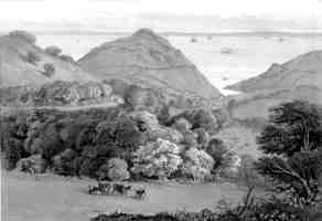
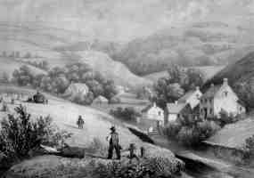 Contemporary prints support this
romantic idyll (above left and right). The print on the left, looking
down the valley, shows the 1830 turnpike road to Barnstaple, with Hele
in the distance. There are some buildings at the
bottom of Hillside Road (then the main road to Ilfracombe) and below this a
farm which Gosse called the Tea Garden Inn, to the right are a cluster of cottages beside the mill.
The print on the right, looking up the valley, shows the mill in a group of
trees, the cottages in Hele Close (now Beach Road) are on the right. They
are difficult to recognise, but the cottage perpendicular to the stream is now
part of 13 Beach Road. The two cottages beyond it have been demolished, the
cottage on the extreme right is now part of a terrace of three flat-roofed
cottages and the cottage beyond that is now 11 Beach Road. Gosse wrote "the houses are partly placed around the
base of Hillsborough, up whose steep sides the gardens extend, and partly up a
lovely valley. A brawling brook comes down through this wooded glen, turns the
village mill-wheel, and runs off to the sea between two walls, one of which
forms a causeway about a yard in width, between the cottage-doors and the
water-course". (2)
Contemporary prints support this
romantic idyll (above left and right). The print on the left, looking
down the valley, shows the 1830 turnpike road to Barnstaple, with Hele
in the distance. There are some buildings at the
bottom of Hillside Road (then the main road to Ilfracombe) and below this a
farm which Gosse called the Tea Garden Inn, to the right are a cluster of cottages beside the mill.
The print on the right, looking up the valley, shows the mill in a group of
trees, the cottages in Hele Close (now Beach Road) are on the right. They
are difficult to recognise, but the cottage perpendicular to the stream is now
part of 13 Beach Road. The two cottages beyond it have been demolished, the
cottage on the extreme right is now part of a terrace of three flat-roofed
cottages and the cottage beyond that is now 11 Beach Road. Gosse wrote "the houses are partly placed around the
base of Hillsborough, up whose steep sides the gardens extend, and partly up a
lovely valley. A brawling brook comes down through this wooded glen, turns the
village mill-wheel, and runs off to the sea between two walls, one of which
forms a causeway about a yard in width, between the cottage-doors and the
water-course". (2)
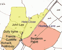 The Tithe map
(left) shows a lime kiln beside the beach,
which may have been still in use. The strange 'dagger' symbol to the right
probably denotes an uncertain boundary.
The Tithe transcription reveals that the properties in Hele Close were held by John Lee, Dolly Irvine and
Francis Cutcliffe. Further along
were gardens rented by Richard Rotenbury
and Ann Maybey, then buildings at the bottom of Hillside Road
held by John Berry. The fields to the top of Hillside road were held by Richard Harding; he
also held the fields down to and including the Tea Garden Inn. These
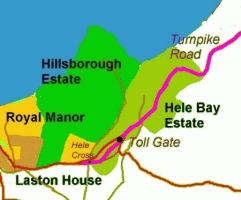
lands were all part of Hele Bay Estate, owned by the Walters’ family.
Hele village belonged to the adjoining Chambercombe Estate, owned by George and John Vye.
(3)
The Tithe map
(left) shows a lime kiln beside the beach,
which may have been still in use. The strange 'dagger' symbol to the right
probably denotes an uncertain boundary.
The Tithe transcription reveals that the properties in Hele Close were held by John Lee, Dolly Irvine and
Francis Cutcliffe. Further along
were gardens rented by Richard Rotenbury
and Ann Maybey, then buildings at the bottom of Hillside Road
held by John Berry. The fields to the top of Hillside road were held by Richard Harding; he
also held the fields down to and including the Tea Garden Inn. These
lands were all part of Hele Bay Estate, owned by the Walters’ family.
Hele village belonged to the adjoining Chambercombe Estate, owned by George and John Vye.
(3)
Although the properties in Beach Road were held by only 3 families in the 1839 Tithe, the 1841 Census shows that there were 30 people living there, in seven families: Lewis, Hill, Pugsley, Ley (Lee), Parker, Irwin (Irvine) and Cuttipp (Cutcliffe). The first small cottages were probably beside the stream; perhaps they flooded and when larger houses were built, they were sited further back (4). By the 1851 Census there were 48 people living in Beach Road, the total population of Hele being 166. Some of these families have familiar names. The Moon's for example, may be related to the maker of Joe Moon's Caves on Hillsborough (see lime-burning). Perhaps John Galliver, given by profession as a limeburner/journeyman, still used the kiln on the beach during the winter. John Hill, who held the mill, was the local blacksmith and is said to have also been the dentist and policeman! John Wilkey and William Stevins are said to have waylaid a smuggler's wagon on its way to South Molton (see smuggling). Descendents of some of these families (e.g. Parker, Galliver and Watts) still live in Hele today, over 150 years later. (5)
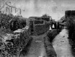
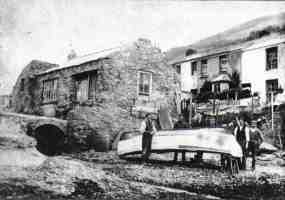
Between approximately 1840 to 1860, larger houses were built back from the stream and Hele Close became known as Beach Road. This photograph of 1897 (above right) shows the lower part of Beach Road before the stream was covered over. On the right of the photograph is the lime kiln, beneath which there is a heap of coal. Below this, in the stream, there is a cart, used to carry coal up the stream to the road, where there was a slipway. Number 9 (now 25) Beach Road is on the extreme left; this was held by John Galliver the Elder until he died in 1859, when it passed to Maria Parker (who later became Rees) and his sons William and John. Perhaps the young girl shown in the photograph is Eve, John the Elder's granddaughter. (6)
 The houses nearest the beach were occupied by the Lewis'; then a common name in
Ilfracombe (there were 63 Lewis' in Ilfracombe in 1851). No doubt they were
constructed by Nicholas Lewis, a stone mason. His son William,
a carpenter and fisherman, is said to have built several boats beside the
beach, including one called the Saucy Lass. This photograph (left) is said to show William Lewis in
1875, standing in front of one of his boats. The stone shed which he used as a store later became
Lewis’ Tearooms and then Bayside Cafe. By the 1891 Census there were four Lewis families in Beach Road. Note the bridge over the stream;
anything delivered by boat would have to be handled twice to get to
the road. (7)
The houses nearest the beach were occupied by the Lewis'; then a common name in
Ilfracombe (there were 63 Lewis' in Ilfracombe in 1851). No doubt they were
constructed by Nicholas Lewis, a stone mason. His son William,
a carpenter and fisherman, is said to have built several boats beside the
beach, including one called the Saucy Lass. This photograph (left) is said to show William Lewis in
1875, standing in front of one of his boats. The stone shed which he used as a store later became
Lewis’ Tearooms and then Bayside Cafe. By the 1891 Census there were four Lewis families in Beach Road. Note the bridge over the stream;
anything delivered by boat would have to be handled twice to get to
the road. (7)
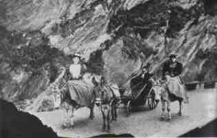
Gosse found Hele to be "inhabited chiefly by gardeners, laundresses, donkey-keepers and other persons, whose subsistence is largely dependent on summer visitors to Ilfracombe." Donkeys were kept by the local women, originally for delivering laundry and then for conveying tourists. The 1891 Census called Maria Rees a donkey chair proprietor and her daughter Sally Galliver (who later took over the business) a donkey chair driver. The average charge was 6d. for ½ mile and 8d. for 1 mile. Donkeys were kept on the coastal slope east of the beach, which consequently became known as Donkey Island. In 1884 W Walters wrote "There is an open and spacious shingle beach at Hele Bay, which is thought by many will be used largely for bathing purposes at no distant date"; this appears to have been the case, since the 1891 Census gives Joseph Cutcliffe's occupation as Bath Chair Proprietor. (8)
The rapid growth in Beach Road was mirrored in the rest of Hele. A Chapel, also used as a Mission School, was built in 1820 at the bottom of Hillside Road (now demolished; some of its back wall can still be seen behind the public telephone box). A National School (now a private house) was built in 1865 near the Tea Garden Inn and in 1868 a new Turnpike road opened between Ilfracombe and Combe Martin (see Turnpikes). Before this, the main route was inland, along Berrynarbor Lane; the coastal route was only a lane (known as Hockey Lane) to the edge of Hele Bay Estate. From Hele there were two routes up the hill to Ilfracombe; along Hillside Road, or past the Tea Garden Inn (the latter route has now gone). The new turnpike road went right between them. The toll-house, beside the old Chapel, appears to have been a Newsagents and there were toll gates across the turnpike road until 1888. (9)
 In the 1890's builders expressed interest in developing Hillsborough
Estate, owned by Mr Bowen May. To save the land from developers,
Ilfracombe Council purchased the Estate for the town in 1895 for £7,500. This
included the coastline from Rapparee Cove around to Hele Beach (left). Rapparee & Larkstone Coves were still part of what was left of
Ilfracombe Royal Manor; as was Brimlands. Larkstone cottage and Laston
House were owned by the Copner family, who had previously owned Hillsborough Estate.
(10)
In the 1890's builders expressed interest in developing Hillsborough
Estate, owned by Mr Bowen May. To save the land from developers,
Ilfracombe Council purchased the Estate for the town in 1895 for £7,500. This
included the coastline from Rapparee Cove around to Hele Beach (left). Rapparee & Larkstone Coves were still part of what was left of
Ilfracombe Royal Manor; as was Brimlands. Larkstone cottage and Laston
House were owned by the Copner family, who had previously owned Hillsborough Estate.
(10)
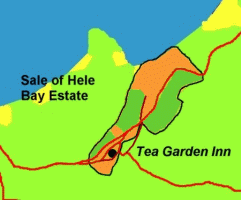
Hele Bay Estate was now owned by the Fosse family (who inherited from the Walters). Somehow a local developer, Thomas Upton, managed to acquire a share; perhaps he knew that the Ilfracombe Gas Company were interested in Hele because of it’s proximity to the beach (the gas works for Ilfracombe were then behind Church Street, a built-up area and inconvenient to supply with coal). In 1895 the Gas Company bought Hele Bay Estate for £5,700 (11). The following year they disposed of the land they didn't need in a public sale (right); the rest was retained (shown orange), including the Tea Garden Inn (later the site of the gas works) and the properties beside the road and stream leading down to the beach - they may have originally been planning to construct a harbour in the Bay. Over the next few years many local residents bought properties that they had formerly leased. (12)
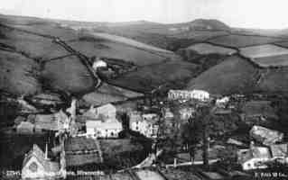
Just before the end of the century, Hele was still a rural idyll. It is said that salmon used to swim up the stream and the millponds were full of eels. This Francis Frith postcard of Hele Village (left) shows the Tea Garden Inn to the right and the National School to the left. Lilian Wilson remembered that "Hele was a very pretty small village.... just the mill and the farm, two small streams, the mill pond and about 30 houses..... [the Tea Garden Inn] used to be such a lovely place. It was an apple and cherry orchard with a stream running along the side and a tea room where people out for a walk or ride could linger and have refreshments. It was especially beautiful when the trees were in bloom" but that was all just about to change! In 1898 the Tea Garden Inn burned down and the Hele Bay Hotel was built, the first building east of the stream below the mill. Two shops were built on the main road in 1900: 18 Watermouth Road was a post office and general store, number 19 was a cobblers. (13)
< Artillery Volunteers Edwardian >
(1) Collapse of Hillsborough 1851
"This hill affords an instructive example of the formation of a shingle beach. About two years ago, one winters night, the inhabitants of the town were affrighted by a tremendous and unaccountable noise, and in the morning perceived that a large portion of old Hillsborough had fallen. It had before presented an uneven and broken slope, covered with bushes and herbage close to the water; but now they saw all this gone, and an abrupt precipice in its stead, as if a giant had taken a rick-knife of suitable dimensions, and had cut off a huge slice from the top to the bottom. The fallen mass of debris formed a vast heap piled against the side to nearly half the height. Up to this time there had been no beach at the foot; the water had been deep to the cliff, and bristled with projecting masses and points of rock. the action of the waves and the weather soon took down the piled heap of rubbish; and in a very few months the whole had assumed its present state. A wide beach was formed by the debris settling itself into the sea; the projecting rocks are quite covered by it; and the fragments of the fallen mountain are already worn into round and smooth pebbles by the rolling surf, so that no one would think on looking at it that it had not been a shingle beach ever since the deluge" (Gosse 1853 p 266-7)
"As the most elevated part of the coast-line where the down comes to a precipitous edge some hundreds of feet above the sea [between Hele and Samson's], there is a narrow but deep cleft in the land, into which we can gaze down from the road. It is an awful chasm, with nearly perpendicular sides; and was formed, as I was told, in one night, about a year ago, by the sudden falling in of the earth. There was still the hedge running along the margin of the precipice, interrupted by the chasm, which had cut it right through. These land-slips are by no means of rare occurrence, and they frequently alter and modify the appearance both of the cliffs and of the sea-margin below." (Gosse 1853 p 293)
"Hillsborough beach was enlarged about 1851 by the fall on a winters night of a large portion of the cliff" (Hall 1879 p280)
"LANDSLIP AT HILLSBOROUGH HILL - A landslip of considerable magnitude, occurred on the sea face of Hillsborough Hill on Thursday night last week. The slip commenced a few minutes after nine o'clock in the evening, and continued with short intervals about an hour; having in that time thrown down to the beach several hundred tons of rock rubble, from the hill-side. One observer describes the sound made by the falling rock as very like that of the running of a vessel's chain through the hawse hole, accompanied by a strong sea breaking on a pebbly beach. As heard from the quay and the Capstone Parade it was likened to thunder or the blowing up of a steamer. As one or two steamtugs were outside the harbour at the time the, latter was regarded when the sound was heard, as a very plausible explanation. Of' late years falls of greater or less extent have greatly the outline of the grand old hill as seen from the sea; there was a time some twenty-six to thirty years ago, when there no beach at all at the base of Hillsborough, but when the part which slopes towards the sea where the present slip has occurred was in appearance like the portion now lying between that spot and Rapparee; that however, is getting back towards 'Old Times,' and many things besides Hillsborough have changed appearances since then." (Ilfracombe Chronicle 1874 Sat. May 2nd)
(2) Views of Hele c1850, Gosse
A postcard from Ilfracombe Museum (ILFCM 6636) says "Hele Nr Ilfracombe 5006" on the front. According to Lamplugh 1984 p 73 this is how Philip Gosse saw Hele in 1853 "emblossomed in gardens and orchards, and half hidden by tall and shaggy elms". There is a copy of this picture in Lamplugh 1996 p 118. It is from an engraving; there are several black and white prints of the engraving in Ilfracombe Museum, copy of one shown above, and a colour tinted version (Topographic prints box, e.g. ILFCM 8039) They have printed beneath "G Rowe, published by Banfield Library Ilfracombe" and c1840 is handwritten.
Engraving of Beach Road c1850, shown above, from Ilfracombe Museum (Topographic prints box, ILFCM 8048) has "Heal near Ilfracombe" printed below it
In 1853 Philip Gosse published "A Naturalists' Rambles on the Devonshire Coast" which is mostly a study of local sea-creatures but there are descriptions of the places he visited and he mentions Hele several times:-
"Now for a gaze inland. Under our feet is the village of Hele, emblossomed in gardens and orchards, and half hidden by tall and shaggy elms. A valley winds up to the left, with a little stream running through its wooded bottom, of which, however, we can scarcely catch a glimpse here. Another lovely vale, that of Chambercombe, leads off to the right, and then curves round parallel with the former; the sides of its bounding hills are covered still more luxuriantly with woods of oak and ask, the dark shadows of which contrast finely with the sunny fields between, cut up by rods and cross-paths like a ground-plan of an estate in a land-agents office. We walk on a little way to the eastern brow of the hill, which is less precipitous than the other. hence we look down upon extensive gardens sloping away from our feet to the cottages on the road side. opposite us rises a broad hill-side covered with fields of corn and potatoes. Between there is the valley, the village-mill, the 'one arch'd bridge' crossing the brook, and the brook itself now in full view brawling and sparkling away to the cove." (Gosse 1853 p 264-5)
"I said that Hele is a picturesque village. The houses are partly placed around the base of Hillsborough, up whose steep sides the gardens extend, and partly up a lovely valley. A brawling brook comes down through this wooded glen, turns the village mill-wheel, and runs off to the sea between two walls, one of which forms a causeway about a yard in width, between the cottage-doors and the water-course. This leads us to the cove - Hele Strand as it is called - an admixture, like all the coves hereabout, of pebbly beach and lodges of rough rock, with many sharp ragged points and eminences rising on every hand" (Gosse 1853 p 130)
"To walk to Hele you go up a quiet lane above the shipbuilders yard, pausing to lean over the iron rail that guards the steep bushy cliff, to watch the busy scene in the harbour. Then down the slope of Quay Fields, over the rustic bridge that strides the deep road leading to Larkstone Cove, between hedges full of blossom, and along the footpath through the corm across Brimlinsfield to the high road where you pass the turnpike kept by turnpike keeper John Barrow - and so down to the Tea Gardens Inn, among its orchards, past the mill and down the side of the stream to the sea." (Gosse 1853, according to ICTG 1985-6 p 2)
(3) Tithe Map 1839
Ilfracombe Museum have the original Tithe maps for Ilfracombe, c1839, and a transcription of the land-owners and holders in 1839, prepared by the present Curator, Mrs Sue Pullen. This was the last Tithe and only mentions the principal owners or holders of properties; not all of the tenants. The Tithe map for Hele Bay, of which a detail is shown above, is from Ilfracombe Museum ILFCM 17325 map 1. It shows the lime kiln on Hele beach and nearby is a dagger, presumably to mark an uncertain boundary.
There are no Moon or Galliver families in the 1839 Tithe, although there are several Lewis' (not around Hele). Some entries from the transcription (Ilfracombe Museum ILFCM 17326/22-24) are below, in the order Plot number (which relates to that shown on the map); owner; holder; address; land type (Pleck is probably meant to mean Public):-
57 Joseph & Thomas Walters & William ?; John Lee; Hele Close; pasture
58 Joseph & Thomas Walters & William ?; John Lee; Hele Close; arable [between stream & Hockey Lane]
59 Joseph & Thomas Walters & William ?; Benjamin Pigott; Hele Close; arable
60 Joseph & Thomas Walters & William ?; Benjamin Pigott; Cleave; rough
61-63 George & John Vye; -; Hele pasture, Garden, House, building, courtledge, etc
64 Richard Rotenbury; in hand; house, building & garden
65 Philip Watts; John Fisher; house and garden
66 Thomas Watts; in hand; Hele mill
67 John Lee; in hand; cottage & garden
68 Dolly Irvine; in hand; cottage & land
69 Francis Cutcliffe; in hand; cottage & land
70 Joseph & Thomas Walters & William ?; Richard Rotenbury; garden
71 Joseph & Thomas Walters & William ?; Anne Maybey; garden
72 John Berry; in hand; buildings and land
73 Ann Mabey; John Popham; 3 houses & garden
74 Joseph & Thomas Walters & William ?; Pleck; pasture
75 George & John Vye; -; Pleck; meadow
76 George & John Vye, -; house and garden
77 William Pugsley; in hand; house, garden & orchard
78 Joseph & Thomas Walters & William ?; Richard Harding; House, garden & orchard, pasture
79 Joseph & Thomas Walters & William ?; Richard Harding; garden [between Hillside Rd & Main Rd]
80 Joseph & Thomas Walters & William ?; Richard Harding; young orchard, pasture [between Hillside Rd & Main Rd]
81 Joseph & Thomas Walters & William ?; William Pugsley; Higher Hele Close [probably Cross]; arable
82 Joseph & Thomas Walters & William ?; Richard Harding; Little Hele Cross; arable [top Hillside Road]
83 Joseph & Thomas Walters & William ?; Richard Harding; old orchard; arable [between Hillside Rd & Main Rd]
84 Joseph & Thomas Walters & William ?; Richard Harding; part of Hele Cross; arable [between Hillside Rd & Main Rd]
85 Joseph & Thomas Walters & William ?; Richard Harding; lower orchard; pasture
1542 Joseph & Thomas Waters & William Holse; Edward Lovering; Oakey; arable
1543 Joseph & Thomas Waters & William Holse; John Fisher; arable
1544 Joseph & Thomas Waters & William Holse; Edward Lovering; Oakey; arable
1545 Joseph & Thomas Waters & William Holse; George Hill; arable
1546 Joseph & Thomas Waters & William Holse; John Barry; pasture
(Transcription of 1839 Ilfracombe Tithe, Ilfracombe Museum)
(4) 1841 Census
This is the first Census. There is a transcription in Ilfracombe Museum. Unfortunately, the addresses are not given (other than Heale) and it is not known to which properties the folio numbers refer. The different households, however, are for the most part, listed in order.
100 Heale James Stevins, Ag Lab 40, Elizabeth 35, Eliza 15, James 12 or 20, Thomas 10, William 7, Henry 4
100 Heale George Watts, Ag Lab 40, Mary 45, Elizabeth 7, Thomas 15, John 1
100 Heale Thomas Justar? Ag Lab 40, Betsey 40, Eliza 11, ???, Thomas 7, Jane 1
101 Heale John Berry or Beny, Mason 40, Ann 40, Ann 14, Sarah 7, Eliza 5
101 Heale Francis Cuttipp?, Ag Lab 40, Dorothy 45, John15, Ann 12, Mary 9, Joseph 6
101 Heale Mary Irwin 70, Dolly Irwin 30
101 Heale Henry Parkes or Parker, Ag Lab 40, Betsey 40, Ann 10, Mary 8, Maria 2
101 Heale John Ley, Ag Lab 45, Jane 45
101 Heale William Pugsley, Ag Lab 75, Elizabeth 70, John, Ag Lab ?
102 Heale George Hill, Ag Lab 45, Mary 45, Elizabeth 11, William 11, Elizabeth 70
102 Heale Nicholas Lewis, Mason 35, Jane 35, Thomas 12, Mary 10, Nathaniel 8, Ann 5, William 2
102 Heale William Pugsley, Shoe mender 35, Mary 9, John 7, Jane 6, William 4, Elizabeth 2
102 Heale Humphrey Bovins, Ag Lab 65, Alice 60
102 Heale Susan Hill, Laundress 30, Eliza 20, Mary 5
102 Heale Mill Thomas Watts, Miller 45, Susan 50
103 Heale John Jewill, Ag Lab 60, Mary 60, Elizabeth Geane 4, Mary Richards, fs 15
103 Heale John Hill, Blacksmith 30, Mary 25, William 1, John 5, Mary 3, Betsey 14, Elizabeth 15, Thomas Harding app 20
103 Heale Ann Rotenbery or Ratenbery, 65
103 Heale John Popham or Papham, Mason 30, Susan 25, William 6, John 3, Thomas 1
103 Heale John Rattenbury or Rottenbury, Seaman 30, Ann 25, Mary 2 months, Caroline Keys or Kays, fs 20
103 Heale John Popham or Papham, Ag Lab, 75
103 Heale Alice ? 65, Mariann Green 23 or 28, James Green 1
104 Heale Richard Rottenbury, Mason 40, Elizabeth 35, Mary 20, Hannah 14, Hester 12, Richard 10, John 7, William 4
104 Heale John Staddon, Ag Lab 40, Elizabeth 13
104 Heale John Rowe?, Ag lab 40, Betsey 35, Elizabeth 11, William 6, Thomas 5
104 Heale John Fisher, Farmer 55, Mary 55, Charles 20, John 15, Matilda 11
104 Heale Richard Harding, Gardener 50, Elizabeth 30, John 15, Elizabeth? 7, William 5, Prudence Leworthy, fs 15
104 Heale Thomas Colwill, Lawyer 45, Ann Cadis or Codis 35, Mary 7, Martha 1, George Chugg 60
108? Chambercombe Alice Soosaler? 70, Ann Soosaler? 20, John Stevins 5
(Transcription of Ilfracombe 1841 Census, Ilfracombe Museum)
(5) 1851 Census
This is the second Census. There is a transcription in Ilfracombe Museum. Again, addresses are not given (other than Heale) and it is not known to which properties the folio numbers refer. The different households, however, are for the most part, listed in order. In the 1851 Ilfracombe Census there were 3 Galliver families in Ilfracombe; 6 Moon familes; No Samson or Sampson; 26 Lewis' families (63 Lewis' in total).
164 Nicolas Lewis (Stone mason) 42, Jane (wife) 45, Ann 15, William 12, Nicholas 9, Keiza 6, Elizabeth 4, John 10 months
164 John Jewell (Ag Lab) 68, Mary (wife) 68, Elizabeth Grant (Gd) 14, Elizabeth Statton (Servant) 23
164 Elizabeth Parker (Charwoman) 47, Ann (Cw) 22, Mary (Cw) 18, Maria 12, Henry 7
165 John Statton (Ag Lab) 52, Grace (wife) 50, John 8, Mary 7
165 John Wilkey (Ag Lab) 34, Sarah (w) 27, Edwin 4, George 2
165 Ann Rottonberry (Pauper) 80, Elizabeth Jones (dau) 34 cook
165 Elizabeth Peake 27, William 3 months, Mary A (M-in-L) 54 nurse
165 John Rottonberry (Mariner) 45, Ann (w) 33 Laundress, Mary A 9, John 7, Margaret 5, William 7 months, Ann Allen (servant) 19
165 Elizabeth Grant (Laundress) 43, Mary A 12, Jane 10, John 7, Susan 4
165 John Bryant (Ag Lab) 33, Betsey (w) 23, William 1
165 Richrd Rottenbury (Stone mason) 50, Elizabeth (w) 48, Anna (Dressmaker) 21, Esther 19, Richard 17 (Mason), William 14, Amelia 7, William Watts (Blacksmith/journeyman) 21, Fanny Crocker (Schoolmistress) 28
166 William Jewell (Ag Lab) 40, Mary (w) 28 Laundress, Mary 7, Susan 2, Mary Wilkey (Servant) 21
166 William Pugsley (retired) 84, Elizabeth 82
166 William Pugsley 49, shoemaker, wife Mary 50, William 14, Elizabeth 12, James 3
166 John Hill, 40, master blacksmith, wife Mary 43, John 15, Mary 14, William 12 miller, Susan 8 dressmaker apprent, William Weslake, serv 22, James Huxtable, serv 23, blacksmith
166 Robert grant, 34 Blacksmith Journeyman, wife Elizabeth 29, William 3, Elizabeth 1
166 Mary Ridge, 35, Arthur Parcels, son 14, Emily 4, Mary 4, Elizabeth 18 months
166 John Fisher, 68 farmer, John 24 ag lab, Matilda 22, John 7 grandson) William Gould, fs 40,
166 John Burgess, retrd farmer, 73, wife Susan 70, Susan granddndd 17, Elizabeth Jewell 57
166 William Huxtable, thatcher, 43, Agness, wife, 45, Thomas 16, Ann 14
166 Richard Harding, gardener, 63, Elizabeth 42, William 15, Richard 10, George Butler 23, fs
166 John Popham 41, master mason; wife Susan 38, William 15 shoemaker appr, John 13, Thomas 10, Susan 4, John wid. 86 pauper
167 John berry, 50 stone mason, Ann wife 45, Ann 24 dressm, Sarah 17, John 8, Thomas (gson) 7
167 John Rowe, 49 ag lab, Betsey wife 48 washerwoman, Anna 8
167 Francis Norman, ag lab 40, wife Ann 30, Ann 8, Mary 7, George 4, Francis 1
167 - Richard Moon, ag lab, 27, wife Susan 26, sons Francis 4, George 1 month
168 John Galliver, head M aged 53, Lime burner/Journeyman, Wife Betty 50, son John 15
168 James Stevens, 53 ag lab, Elizabeth wife 49, James 22 master shoemaker, Thomas 20 ag lab
168 Francis Cutcliffe 56 ag lab, Dorothy wife 56, Ann 21, Mary 19, Joseph 16
168 George Watts, 53 ag lab, Mary 54, Betsy 17,
168 george watts 29 ag lab, Ann wife 31, Anna 1
168 John White, 57 ag lab, Betsy wife 48, Matilda 15, James 7
168 George Hill, 58 ag lab, Mary wife 57, Betsy 20, William 20
168 John Ley 50 ag lab, Jane wife 56, Jane granddaughter 10
168 John Brimbly 44 ag lab; wife Betsy 40; Anna 8; Elizabeth 5; Eliza 2
169 - Thomas Moon ag lab 36, wife Sally 44, sons Thomas 9, William 8, Robert 6
169 - one house uninhabited
169 - John Cutcliffe 27 ag lab, Fanny wife 24, John Vine, servant 13
*end of village of Heale*
(Transcription of Ilfracombe 1851 Census, Ilfracombe Museum)
"History of Hele Mill. Hele mill said to be 200 years old and still in use by the owner, Mr Luther Salway (it was in use until about 1950). In early days the miller and his family lived where the present granary is. The earliest owners, Mr John Hill about 1830, was also the village dentist and policeman. The baton he used when active as the custodian of the peace, is preserved by Mr Salway of Moles Farm. John Hill died in Jubilee year and his wife known as granny Salway died in 1932, 95 years old. The original stones are still for grinding, but the wooden water wheel has been replaced by an iron one. Donkeys carried the sacks of grist on their backs" (Hand-written article in Hele box, Ilfracombe Museum, based on IC 1933 Sept 1st p 6) [Thomas Watts held Hele Mill in the 1839 Tithe and was the occupier in the 1841 Census, John Hill was the occupier in the 1851 Census]
(6) Beach Road
February 3rd 1860 - Mrs Ilett Stevens Fosse, Mrs Mary Bowen Walters [both widows, presumably of Joseph and William Walters] and Mr Thomas Walters ‘Gentleman of Lewisham’, to Mr William Galliver, labourer, on 99 year lease, 89 perches [160 perches = 1 acre] of land previously occupied by John Galliver the Elder [died 25th Dec 1859] in 3 names, William Galliver, 26yrs, John Galliver, brother, 34 yrs, and Maria Parker, daughter of Harry and Elizabeth Parker, 20yrs. Yearly rent £3 6s 9d, Heriot fee (on death) £1, reappointment fee £15 signed ‘the mark X of William Galliver’ (A Galliver, deeds) This is now known as 24/5 Beach Road.
There were three Galliver families in Hele in the 1891 Census. Plots 46 & 47 are 24/5 Beach Road:
33 James Galliver, Head, Male 28, Mason’s Labourer; Emily Galliver, Wife, Female 26; Florence Galliver, Daughter 3; Harry Galliver, Son 2
46 John Galliver, Head, Male 27, Shoe Maker; Susan Galliver, Wife, Female aged 26; Eve J Galliver, Daughter aged 1
47 Maria Rees, Head, Female aged 51, Donkey Chair Proprietor; Sarah J L Galliver, Daughter aged 20, Donkey Chair Driver (employee); William H Galliver, Son aged 17, Mason’s Labourer (employee)
(Genuki website, Ilfracombe Census 1891 RG12/1778, Enum Dist. 13, Transcribed by Bob Muchamore, www.cs.ncl.ac.uk/genuki/DEV/Ilfracombe/index.html)
A photograph of Beach Road before the stream was covered over, shown above, was taken looking along the stream to the sea. The family group are standing outside the entrance to (then) 8/9 Beach Road; the wall is still there today although about two feet shorter. There is a heap of coal leaning against the lime kiln on the right and there is a cart in the stream. There is an original photograph of this in Ilfracombe Museum which has "The road to Hele Beach 1897" written on it (Hele box ILFCM 2045) There is a copy in Pullen & Harding 2003 p 67
"The mill stream tumbled over a stony bed down to the sea, and the only means of reaching the bay was by riding on horse or donkey down the water course or a narrow stone-flagged footway at the side. The stream now runs in a channel under the roadway." (Ilfracombe Chronicle Sept. 1st 1933 p 6)
(7) 1875 Lewis'
Photo of people beside a boat on the beach, shown above (from C Hancock). The gentleman in front of the boat is said to be William Lewis. In the background is a stone shed, which later became Lewis’ Tearooms and is now called Bayside. The stream is still open - there is a bridge to the left of the shed which shows that it would not have been possible to carry coal, by horse and trap, from the beach all the way up the stream. The original copy had "E Gratton Phillipse, Kingsley, High Street, Ilfracombe" on the mount and another copy has "Boat building at Hele Bay c1875" written underneath.
There were four Lewis families beside the beach in the 1891 Census:
49 Eliza J Lewis, Female aged 21, Dressmaker
50 Elizabeth Seriven (?) Head W 43, Laundry Woman (employee)
51: Thomas N Lewis, Head, Male aged 61, Agricultural Labourer; Elizabeth Lewis, Wife, Female aged 63, Laundry Woman; Percivel, Grandson aged 7
52 William Lewis, Head, Male aged 42, Carpenter; Mary Lewis, Wife, Female aged 51; Nathaniel Lewis, Son aged 15; Martha Lewis, Daughter aged 13; Alice Lewis, Daughter aged 11
53 Jane Lewis, Head, Female aged 85; Thomas P Gibbs, Grandson, Male aged 24, Seaman; Annie A Gibbs, Grand-daughter, Female aged 23
(Genuki website, Ilfracombe Census 1891 RG12/1778, Enum Dist. 13, Transcribed by Bob Muchamore, www.cs.ncl.ac.uk/genuki/DEV/Ilfracombe/index.html )
"It might be mentioned that yacht-building was carried on at Hele for many years by the Lewis family, and among the yachts were the Saucy Lass, Foam, Blue Ribbon, Teaser and Maud" (Ilfracombe Chronicle Sept. 1st 1933 p 6)
"The following is from the Story of Ilfracombe Harbour by TRL Green 1943. 'In the latter half of the 19th and early part of this century, several small sailing cutters, including the Teazer, owned by William H Barbeary, the Saucy Lass built by William Lewis at Hele and owned by Nicholas Barbeary, the Foam, owned for many years by Samuel ley and afterwards by Jack Barbeary and the Polly, owned by Tom Williams, were popular with visitors to Ilfracombe." (Handwritten notes, Ships box, Ilfracombe Museum)
"HELE. William Lewis built his cutter Saucy Lass on the beach at Hele. The year is uncertain as she was not a registered vessel, but it was probably in the early 1890's. He used her for sailing trips with visitors in season, and for fishing in winter" (Typed notes in Ships box, Ilfracombe Museum, handwritten note 'Taken from National maritime Museum, Shipbuilding in North Devon')
(8) Donkeys & Tourism
"A pleasant walk of about a mile leads to Hele, a picturesque village, inhabited chiefly by gardeners, laundresses, donkey-keepers and other persons, whose subsistence is largely dependent on summer visitors to Ilfracombe. There is a foot-path through the fields to it, which is pleasanter than the carriage road, and is a favourite walk with me" (Gosse 1853 p 128)
"Chambercombe, the site of the mansions of the Champernons erewhile lords of the manor of Ilfracombe, is a beautiful valley, reached by passing along the road at the back of Lastone Terrace (a row of large houses overlooking the harbour), and after reaching a thatched cottage close to the road, taking the first turning to the right. The woods and lanes about Chambercombe are very beautiful, and endless varieties of mosses, ferns, and wild flowers are found in its neighbourhood. Passing the farm house at Chambercombe, the visitor can extend his walk to Common Farm, which is situated at the spur dividing two valleys, each of which forms a pleasant ramble for the lover of quiet sylvan scenery. The walk to Chambercombe and Common may be varied on the return by taking the lane on the right - just at the farm yard of the latter, which leads to the hamlet of Hele, thence home by turnpike road. To this little hamlet is a pleasant walk on an evening, being within easy distance of the town, on the Lynton road. It lies at the mouth of the Chambercombe valley, and there is an open and spacious shingle beach at Hele Bay, which is thought by many will be used largely for bathing purposes at no distant date. There are many pleasant sites for building here, that will no doubt be taken up in the course of time. Towering over hele and sheltering it from the winter gales is Hillsborough Hill. This is a favourite walk with tourists to whom it is thrown open, the Local Board having rented it from the owner so that the public may have the privilege of enjoying the glorious panorama from its summit, comprising the Bristol Channel from far below Lundy Island on the west to the Foreland on the east, the Welsh hills northwards, together, with a bird's-eye view of Ilfracombe and the hills surrounding it. It is reached by passing along the path in front of Lastone Terrace and crossing through a field near the Brimland's Barn, keeping to a small footpath, which leads round the western side, and thence to the top. There is also a path round its eastern slope forming a charming and pleasant walk leading to the practice battery of the 14th Devon Artillery Volunteers." (Walters 1884 p 31-32)
The 1891 Ilfracombe Census has the following entries of persons using donkeys for their profession:
38 Mary A Cutcliffe, 58, Donkey Driver
39 Joseph Cutcliffe Head 55, Bath Chair Proprietor, Mary Wife 45, John H Son 20 Cab Driver (employee), Grace Tooze Sis 51 Dressmaker (employee)
47 Maria Rees, Head, Female aged 51, Donkey Chair Proprietor; Sarah J L Galliver, Daughter aged 20, Donkey Chair Driver (employee); William H Galliver, Son aged 17, Mason’s Labourer (employee)
(Genuki website, Ilfracombe Census 1891 RG12/1778, Enum Dist. 13, Transcribed by Bob Muchamore, www.cs.ncl.ac.uk/genuki/DEV/Ilfracombe/index.html )
"Donkey Island was so called because the old washer-women of the village used to leave their donkeys there when not employed in delivering the laundry linen." (Ilfracombe Chronicle Sept. 1st 1933 p 6)
"Donkey chairs from Ilfracombe used to take visitors and people not well enough to walk, for rides. They were much like a big arm chair with a hood that could be used up or down, it was for protection from sun or rain or a cold wind. The donkeys were very well kept. There was a stand for them, and for horse-drawn carriages, underneath the high bank that was opposite where Pedlar's shop is now. There was also another stand underneath the War Memorial where the buses have a stopping place now. There was even a big shelter there, not for the public but for the cabmen to rest in and to eat the meals that they carried with them.....The Misses Challacombe and Sally Galliver and others used to get a good living with the donkey chairs. I think the Evans’ family was the last to hire them for public travel" (Wilson 1976 p11)
"Prices found in old advertisements dated towards the latter part of the 19th century....Wheel chairs or donkey chairs 6d. first half mile, after first mile 8d. per mile" (Wilson 1976 p 12)
"Donkey chairs, and donkeys were hired from Mrs Sally Galliver, following on from her mother Reese. She had a little business bringing visitors from Ilfracombe to Hele where they could have a strawberry tea, or a walk in the orchards around the tea Gardens Inn, which were open to visitors at a moderate charge. The Tea Gardens inn was where the Gas Works were built later on, and was burned down in 1898. The tenant at the time was Richard Benoke. Sally Galliver's donkeys and little carriages were a familiar sight on Ilfracombe's sea front, and were also used as transport to the theatre in the evenings" (ICTG 1985-6 p 3)
"For the lazy or infirm visitor to Ilfracombe a donkey cart or donkey ride was a popular means of touring the sights. This photograph dates from the early 1890’s but donkey transport had been available to visitors for at least 100 years before that" This picture is shown above (Horridge 1986 caption to plate 65)
"A bashful moke peeks out of a hut at Larkstone. His reluctance is understandable. Today you are not allowed to get on the back of a donkey - in this country at least - if you weigh more than eight stone. A century ago you could have hired one - regardless of your weight - to take you up Hillsborough and back. No wonder he wants to stay in the hut. The caption is the title of a popular music hall hit from 1905. Note that the photographer has also written ‘stick no bills’ on the fence" (Caption to Swift 2001 plate 1, not shown)
(9) Schools, Chapels
"In 1820 a Mission School was started by Rev John Basle." (ICTG 1985-6 p 2)
"The National School was built in 1865 by Captain Williams of Watermouth Castle, at a cost of £360. The School took 50 children. The School-Mistress in 1893 was a Miss Vince. Then came Miss Hebditch and Daisy Channing, and later Miss Neede and Miss Cotton Amy. In much more recent years Jeanette Chandler used to teach at Hele School, and was the wife of the Vicar Rev. Arthur Chandler." (ICTG 1985-6 p 2)
1865 - A National School/Church opened in Hele (Campbell 1986 p10)
(10) Purchase of Hillsborough Estate by Council 1895
From 1880-1886 the quarry on Hillsborough was used as a sorting station for waste. (Pat Barrow 3/1/93 IM Hillsborough folder- from an article that proposes an archaeological dig in the quarry presumably before the transmitters were sited there)
A NEW PARK FOR ILFRACOMBE, PURCHASE OF THE HILLSBOROUGH ESTATE. Hillsborough Estate - a most lovely spot - is saved from the builder's hands. Hillsborough Estate - which commands the most charming landscapes and marine views in the kingdom - is saved from private speculators. Hillsborough Estate - full of grandeur, is now owned by the Ilfracombe people. The whole of the property has been bought by the members of the Ilfracombe District Council for the townspeople for ever at the price of £7,500, and the purchase is one which no sensible ratepayer can grumble at - in fact it is a bargain. Hillsborough Estate, which the council has secured for the town, comprises in reality over 100 acres, 60 acres of which is grazing land, the remaining 40 acres or more being rocks, cliffs, etc. There are included in the sea front, Swallow Hole Beach, Broad Strand Beach, Beacon Point, Blythe's Cove, right up to Hele Beach, which, of course, takes in the Volunteer Artillery Gun Battery. With a little coast access could be easily made from the lower part of the hill to that fine beach of Broad Sands, and here the town would possess at once what it stands really in need of - a free bathing place, and a splendid stretch of sands, where large numbers of people could be accommodated. According to the ordnance map Hillsborough Estate, beside the above, contain two meadows to the east of Larkstone Park where the flagstaff is, and bounded on the south by the Combmartin road right up to the coast, and on the north by the coast line. The two meadows, which are about nine acres in extent and can be used for recreation purposes, are bounded on the east by Brimlands Barn Field, so that the Council have purchased the whole of the land north of Brimlands Barn Field, including the Barn itself, and the two meadows already referred to. Rapparee Cove is not in the Estate or Brimlands Barn, these two latter being owned by the Weld Estate, and they will act generously towards the town. If those concerned cannot part with Rapparee Cove, and the land near, perhaps they will be inclined to dispose of Brimlands Barn Field. It is most gratifying to know that the whole of the sea front from Rapparee Cove to Hele Bay belongs to the Hillsborough Estate, but all the land above does, right round to the coast line to Rapparee Cove, which is south west to the coast, Hele Bay being the eastern extent. To more particularise the Estate, it might be well to add that it is reached from the Rapparee Cove end, or in other words the Ilfracombe side, when one leaves the enclosed path, which is a right of way through Mr C Copner's property - one field having the path through and bounded on the left side by Combmartin Road from Ilfracombe, the path to the left of the footpath leading to the hill. Up to 23 years ago the Estate was rented by farmers for grazing purposes, but about 1872 it was let to the Ilfracombe Local Board by Mr Bowen May, for a term of 14 years at an annual rent of £90 a year, the Board having the right to sub-let, which they did to a Mr W Day, Butcher, High Street, he paying that amount for the same, with the privilege of a large ash heap, whilst the public were allowed to go up the hill itself. When the 14 years lease expired, another of eight years on the same terms was granted, but a short time ago, Mr Day's rental was reduced to £70 a year, through the Local Board depositing ashes elsewhere. At the expiration of this second lease, the board asked for an extension, but when informed that that the Estate had been let to Mr Rose for building purposes, he agreeing to pay £200 a year in ground rents. To help this, Mr Rose offered the Board the fringe of the hill with the right of way to it, for £100 a year. The Board declined the offer, but made one of £75. Here the matter remained in abeyance for some time until at last it became known that another builder was after the same property, as well as a gentlemen who wished to close the hill, except on payment of a toll. This would only apply to the fringe of the hill. Mr Rose's offer also confined itself to the hill, the Board to build a wall, dividing the property, which it was proposed to erect houses on. To settle matter, Mr Bowen May wrote the Council asking them to name a price for Hillsborough, Mr Rose's negotiations having fallen through. The Council offered at first £75 a year, then £90, and next £100, all of which Mr May declined. £200 was the sum next named. Mr May refused, and the Council fearing that the property would be lost to the town forever, decided to send a deputation to London to interview Mr May. Mr H Braund and Mr F Brede formed the deputation, and Mr May asked £300 a year in perpetuity. Pressure was brought to bear and Mr May agreed to sell the whole of the Estate at 25 years purchase. That being capitalised made £7,500, which Mr May signed an agreement to take. The deputation reported to the Council on Wednesday morning, and the offer was closed with. Upon the same being made known, satisfaction was expressed throughout the town. By the purchase of the two meadows the public will have right of way to the hill much nearer than at present is the case. With Brimlands Barn Fields, Ilfracombe would possess a park and recreation ground in every sense of the word. Of course application will be made to the local Government Board for sanction to borrow the money, and there is a general expression there should be an opening day, followed by a banquet. Twiss and Sons Illustrated Guide to Ilfracombe and North Devon contains the following:- Hillsborough Hill is a prominent feature in the immediate coast scenery of Ilfracombe, as it is a bold and rugged headland some 447 feet in height overlooking the harbour. Traces of a Roman encampment are found on its southern slopes and the original name is said to have been Hele's Burrow. Although private property, this hill is open to visitors, who will find from its summit one of the most beautiful and extended views in the neighbourhood. Arrived at the brow of the hill, the visitor will notice the blue waters of the Bristol Channel, the rugged coast line, the town, and country surrounding it, whilst in the northern distance the blue mountains of Wales - which one clear day are visible from, Candy Island in the west to Penarth Roads eastwards - all lie stretched out like a map before him, with Lundy Island, twenty-one miles distant in the direction of the setting sun, and the steep precipitous hillsides of the foreland, another twenty miles up Channel. Hillsborough Hill is a favourite evening ramble to watch the sun set, but it is also an equally glorious sight to see it rise - assuming there are those who will get up so early on a summers morning to do so. Hillsborough Hill is reached by walking along the Lynton Road or the pathway through the fields near Brimlands Farm, and thence by a short lane to the hill itself. On the eastern side is the practice battery of the Volunteer Artillery, and is reached by a grassy path skirting the hill. Visitors are requested not to take their dogs on the hill as there are a number of sheep grazing on it, and may have been driven over its precipitous cliffs" (The Ilfracombe Gazette & Observer June 1st 1895, from typed copy in Hillsborough folder, Ilfracombe Museum)
"In 1690 ‘Elsborrow’ was owned by Simon Somers and was conveyed to the Bowen family in the C18th a member of which, Miss Elizabeth Bowen, married Rev James May." (Undated newspaper cutting, probably from when Hillsborough was Scheduled in 1978, Hillsborough folder, Ilfracombe Museum)
"That it [the sale of Hillsborough] included pasture implies that the land had been used for grazing up to the time of the sale. A post-medieval boundary consisting of a wall of vertically coursed stones survives...cutting off the headland on the seaward side of the earthworks. The site continued to be grazed until WW2, however photographic evidence from postcards of the 1930’s shows that scrub was accumulating on the slopes by this time. The paths cut into the cliffs and running around the headland were created for the use of the public shortly after purchase. Shelters were constructed and a small tearoom existed by 1925." (Walls 2000 p 8)
(11) Purchase of Hele Bay Estate by Gas Company 1895
"1837 - Stabb’s and Banfield of Ilfracombe Sea Bathing Company have formed the Ilfracombe Gas Company and are building the gas works at the back of Church Street" (IMN 2000 p 7)
"1838 - Ilfracombe is lit by gas and gas lamps have replaced the feeble light in the Lantern light house" (IMN 2000 p 7) "The Ilfracombe gas lighter has failed to light the town lamps, as he was drunk" (IMN 2000 p 7)
1896 - 11th November - Indenture between Thomas Dennis Wivell, Richard Lake, William Claude Raferel and Ilfracombe Gas Co, Charles Edward Roberts Chanter recognising part sale to Charles Edward Ball of 1896 for £1145 of land from Hillside Road to Beach Road, including land between Hillside and Combmartin road including the Chapel, 9 freehold cottages, 4 acres, 2 roods, 32 perches, occupation of George Summerville, Sarah Thadwell, William Webber, Adelbert Stevens, William Watts, David Delve, Frederick Delve, Thomas Watts, Jane Hancock, William Hancock, William Edwards, John Moule (Campbell 1986 pp 51-3) This contained the following memo’s:
1895 - June 28th (or 22nd?) - Between Eliza Eleanor Fry, Ilett Sarah Fosse, John Joseph Fosse, Thomas Parminter Fosse, Alexander Jane Fosse, Charlotte Elizabeth Fosse, Thomas Upton and Thomas Dennis Wivell, Richard Lake, William Claude Raferel of land which probably included that above sold to Charles Ball, plus most of the land from the main road to the sea plus the land on which the gas works were built ALSO memorandum of same date between Thomas Dennis Wivell, Richard Lake, William Claude Raferel and Ilfracombe gas Co, Charles Edward Roberts Chanter for £5700 ALSO memorandum that £1145 was a part sale to Charles Edward Ball and that £5700 was still owed in 1896.
(12) Sale of Hele Bay Estate 1896
Sale Particulars
1896 - October 1st - Sale of Hele Bay Estate, by Mr Edward Gibson, At the Royal Clarence Hotel, in 4 Lots:-
Lot 1:
"Five Freehold Cottages and the Gardens Grounds and Fields near or adjoining thereto, and containing together 3a., 3r., 0p., or thereabouts, and as the same is now in the occupations of William Webber, William White, John Lerwell, George Kingdom, John Stevens, William Henry Webber, William Hancock, William Edwards and John Moule" [This is the area to the north of the main road between Hillside Road and Hillsborough Park Road]
Lot 2:
"The whole of the Freehold Cottages, Gardens and Lands, containing 7a., 2r., 29p., or thereabouts, to the seaward side of the House occupied by Wm. Rottenbury, including such house. This property consists of, and is let, as follows:-
All those 4 cottages occupied by Annie Gibbs, William Lewis, Thomas Lewis & Elizabeth Scrivens....
Also 2 cottages occupied by William Peake and William Duggleby...
Also 2 cottages... occupied by Maria Reece and John Galliver...
Also the cottage... occupied by Ann Blunt...
Also 3 cottages... occupied by John Pedrick and Thomas Pedrick, and held by Mary Jane Ley....
Also 2 cottages... occupied by Thomas Moon and William Rottenbury...
Also cottage... workshop and premises occupied by William Herepath Watts...
Also 2 cottages.... occupied by Charles Snow and Thomas Jeffery, and Mary Anne Cutcliffe, and held by Francis Cutcliffe...
Also 3 cottages... occupied by Richard Clatworthy, Samuel Rottenbury and William Rottenbury, and held by Richard Rottenbury..."
Lots 3 & 4:
"Consist of the Enclosures of Land....contains altogether 14 acres and now in the occupation of Thomas Pedrick and Maria Reece"
(1896 Sale of Hele Bay Estate, Sale Particulars, Hele box, Ilfracombe Museum)
(13) Hele at the end of the 19th century
Photograph (postcard) of Hele shows the Tea Garden Inn, before the gas works were built. Says on front "22945 The Village of Hele, Ilfracombe, F Frith & Co" Copyright the Francis Frith Collection www.francisfrith.co.uk It must date from before 1898 when the Tea Garden Inn burnt down. The number dates it to early 1890 (1890 started with 22421; 1891 with 28140 see www.johnowensmith.co.uk/histdate/friths.htm )
Lilian Wilson talks of visiting Grandmother Widden at Hele "Hele was a very pretty small village in those days, just the mill and the farm, two small streams, the mill pond and about 30 houses. Mostly these were cottages, some in the village near the farm and some down the beach road.....Gran baked all our bread.....There were no gas or electric ovens in Hele in those days, not until they decided to remove the gas works at Wilder Road to Hele, which entirely ruined the village. Where they built the gasworks used to be such a lovely place. It was an apple and cherry orchard with a stream running along the side and a tea room where people out for a walk or ride could linger and have refreshments. It was especially beautiful when the trees were in bloom" (Wilson 1976 pp 35-36)
"In 1898 Hele Hotel was built after a fire had destroyed the Old Tea Gardens Inn" (ICTG 1985-6 p 5)
"The millponds used to be teeming with eels, which were caught in a wicker trap, set above the water-wheel. It is said that many people paid their rent in eels. The stream ran openly down to the beach. There is a list of owners and tenants from 1870. The millstones came from Wales, and it is likely they came by ship and were landed on the beach." (ICTG 1985-6 p 1)
The two shops 18 & 19 Watermouth Road were built in 1900. No 19 was originally a shoe menders....No 18 was a Post Office & store (Campbell 1986 p25)