

The Saxons first came to Britain from Germany around 450 AD, invited to fight against the Picts, but they turned against the British and occupied south-east England (1). After their defeat at the battle of Mount Badon early in the 6th century, they left the south-west alone until the mid 7th century when Cenwealh occupied east Devon. In 682, Centwine ‘put the Britons to flight as far as the sea’; possibly along the Great West Way. The Saxon conquest of north Devon was completed in 710, when Geraint, King of Dumnonia, was defeated by Ine of the West Saxons (2).
 Most
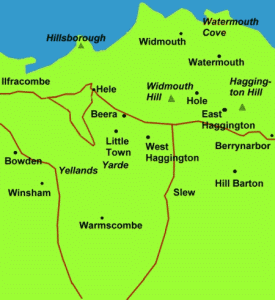
local place names have a Saxon origin and many are derived from a Saxon personal name, for example Ilfracombe, Haggington,
Warmscombe, Mullacott, Lincombe, Winsham and Berrynarbor (left). Smaller settlements tended to
have descriptive names, for
example, Hele, Beara, Littletown, Hole, Widmouth and Bowden (see Place Names).
There are so few pre-Saxon names that it used to be thought that the region was relatively unoccupied when the
Saxons came. Some Saxon names even suggest abandonment, such as Yellaton (there was a
Yelland near Killacleave). But there were too few invaders to found and populate all the
settlements they named and it is likely that in many cases the Saxon's took
over, and renamed,
existing settlements (3).
Most
local place names have a Saxon origin and many are derived from a Saxon personal name, for example Ilfracombe, Haggington,
Warmscombe, Mullacott, Lincombe, Winsham and Berrynarbor (left). Smaller settlements tended to
have descriptive names, for
example, Hele, Beara, Littletown, Hole, Widmouth and Bowden (see Place Names).
There are so few pre-Saxon names that it used to be thought that the region was relatively unoccupied when the
Saxons came. Some Saxon names even suggest abandonment, such as Yellaton (there was a
Yelland near Killacleave). But there were too few invaders to found and populate all the
settlements they named and it is likely that in many cases the Saxon's took
over, and renamed,
existing settlements (3).
Some of the more remote settlements in north Devon appear (on a larger scale Ordnance Survey map) to be associated with field systems having a closed curvilinear boundary. Terry Green has identified over 200 curvilinear field systems associated with a settlement, on the uplands of north Devon and west Exmoor. They appear by their shape to predate the surrounding fields and in many cases their size seems designed to serve multiples of from two to five families. Green suggests that since many have names ending in -ton, -worthy, and -ham, all meaning 'enclosure', they probably date from at least as early as the Saxon period, and some may be earlier. An example of a small oval field system near Ilfracombe that can be clearly seen even on a modern (1:25,000 scale) map, is at Burland near Bittadon. This type of settlement, rather than the hill-slope enclosure or Cornish round, appears to be the origin of most local present-day settlements (4).
When the Saxons were well established, in the winter of 878, early in the reign of King Alfred, Hubba the Dane attacked the north coast of Devon but was slain with over 800 men, and his standard, the Raven, was captured. It has been variously suggested that this battle was at Kenwith Castle near Bideford; Wind Hill at Countisbury; Clovelly Dykes near Clovelly; Cannington Park in Somerset and Castle Hill near Beaford. A few years later there was another attack on a north Devon fort, usually thought to be Burridge hillfort, or possibly Ilfracombe, which had a Saxon defensive tower, now part of Holy Trinity Church. King Alfred may be remembered in the name Ilfracombe, thought to mean Alfred's valley, but it more likely remembers the name of a local lord. The Danes never occupied north Devon, but certainly occupied Lundy (a Danish word meaning Puffin Island) and some graves found there probably date from the 9th century. One of them, called the Giant’s Grave, contained the skeleton of a man of unusual stature, some 8’ 2" tall and it was speculated that he was Hubba (5).
Alfred forced a lasting truce with the Vikings, for which he is the only English King to be called The Great. He probably founded a series of protective burh's, or forts, around the south-west and in North Devon the burh was near Barnstaple, possibly at Burridge. This is known to have required 360 hides, or warriors (a warrior was customarily supported by a hide of 120 acres) and the Manors of Berryarbor, Combe Martin and Haggington, all taxed in the later Doomsday survey at two hides, would have been expected to provide two warriors each for its defence (6).
The Saxons divided the country into Shires as administrative regions. The first occurrence of Devonshire (Defenascir, thought to be derived from Dumnonii) was early in the 9th century. The shires were subdivided into Hundreds early in the 10th century. The local Hundreds were Braunton, Shirwell and Berrynarbor (although Berrynarbor later became part of Braunton Hundred). The Saxons may have inherited a feudal manorial system from the Celts, whereby all land was owned by the King, but individual parcels of land, attached to a local Manor, were granted to different local lords in return for tax and feudal dues (7).
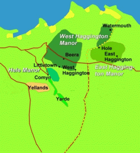 At some time in the Saxon period, Haggington was a relatively
important Manor, being taxed the same as Berrynarbor and Combe Martin (twice
that of Ilfracombe). But, probably when Berrynarbor Hundred was subsumed
by Braunton, Haggington was divided and became marginalised (left).
By the Norman conquest, Haggington was held by three
different Saxon lords: taxed on one hide (West Haggington Manor);
¾ hide (East Haggington Manor); and ¼ hide (associated with West Haggington,
probably the land to the north of Hole farm). This apparently strange division is made
clear by reference to the
Ilfracombe-Berrynarbor parish boundary (shown as yellow dots) (8).
At some time in the Saxon period, Haggington was a relatively
important Manor, being taxed the same as Berrynarbor and Combe Martin (twice
that of Ilfracombe). But, probably when Berrynarbor Hundred was subsumed
by Braunton, Haggington was divided and became marginalised (left).
By the Norman conquest, Haggington was held by three
different Saxon lords: taxed on one hide (West Haggington Manor);
¾ hide (East Haggington Manor); and ¼ hide (associated with West Haggington,
probably the land to the north of Hole farm). This apparently strange division is made
clear by reference to the
Ilfracombe-Berrynarbor parish boundary (shown as yellow dots) (8).
Hele Manor was very much smaller than its neighbours, being taxed on only ½ virgate (15 acres, just sufficient, with some pasture, forest etc, for a peasant family). The location of the original manor is uncertain and may have been at Chambercombe/Comyn or Littletown. Both are associated with oval field boundaries that appear from their shape to predate the surrounding fields although that at Littletown is possibly the earlier, being smaller, better defined and more elevated. The old Ordnance Survey map gives a clue to what may have been the next stage in the development of Hele; to the south of Comyn farm are some fields called Yarde, from Saxon gyrt, meaning an area of land of about 30 acres (a virgate). Perhaps this represents an early Saxon expansion of Hele?
The neighbouring farms of Killicleave, Winsham, Warmscombe and Bowden, all Saxon names, were probably all occupied as part of Ilfracombe Manor. There is one further Saxon name, not shown on the Ordnance Survey map, but known to local people and referred to in the last Tithe of 1839, that is Yelland, which means 'old land'. There is no evidence of a dwelling here and the fields seem to have belonged to Ilfracombe manor (Winsham?) rather than to Hele. When it was 'old land' is not known, but it is said that the side of the valley here has a lot of tetanus in the ground and the stream coming off the hill, just above Chambercombe, is often a brown colour, indicative of iron.
(1) Saxon invasion of SE England
The Anglo-Saxon Chronicles "A.D. 449. This year Marcian and Valentinian assumed the empire, and reigned seven winters. In their days Hengest and Horsa, invited by Wurtgern, king of the Britons to his assistance, landed in Britain in a place that is called Ipwinesfleet; first of all to support the Britons, but they afterwards fought against them. The king directed them to fight against the Picts; and they did so; and obtained the victory wheresoever they came. They then sent to the Angles, and desired them to send more assistance. They described the worthlessness of the Britons, and the richness of the land. They then sent them greater support. Then came the men from three powers of Germany; the Old Saxons, the Angles, and the Jutes. From the Jutes are descended the men of Kent, the Wightwarians (that is, the tribe that now dwelleth in the Isle of Wight), and that kindred in Wessex that men yet call the kindred of the Jutes. From the Old Saxons came the people of Essex and Sussex and Wessex. From Anglia, which has ever since remained waste between the Jutes and the Saxons, came the East Angles, the Middle Angles, the Mercians, and all of those north of the Humber. Their leaders were two brothers, Hengest and Horsa; who were the sons of Wihtgils; Wihtgils was the son of Witta, Witta of Wecta, Wecta of Woden. From this Woden arose all our royal kindred, and that of the Southumbrians also. " (Berkley Digital Library SunSITE website, Online Medieval and Classical Library #17, Douglas B. Killings (ed) 1996 Originally compiled on the orders of King Alfred the Great, approximately A.D. 890, and subsequently maintained and added to by generations of anonymous scribes until the middle of the 12th Century. The original language is Anglo-Saxon (Old English), but later entries are essentially Middle English in tone. Translation by Rev. James Ingram (London, 1823), with additional readings from the translation of Dr. J.A. Giles (London, 1847). The text of this edition is based on that published as "The Anglo-Saxon Chronicle" (Everyman Press, London, 1912). This edition is in the PUBLIC DOMAIN in the United States. http://sunsite.berkeley.edu/OMACL/Anglo/part1.html )
(2) Saxon invasion of N Devon
The beginning of the Saxon conquest of East Devon 665-70 was completed by Centwine’s 682 victory, then there was a pause until 695 when Ine launched an attack from Taunton on Geraint the king of Dumnonia. This phase saw the conquest of North Devon by about 720 and the final conquest of the County began around Exeter 753-7 and concluded about 765. Conquest may not be a correct word since the Saxons probably found little opposition. Much land was deserted. (Hoskins 1954 p 42)
"In 682, the Anglo-Saxon Chronicles tells us, King Centwine ‘drove the Britons as far as the sea’, and this implies the overrunning of the county as far as the Atlantic Coast. Two ridgeway routes are possible for this campaign - either along the Brendon hills to Braunton or via Okehampton to Hartland, and the latter seems more probable" (Sellman 1962 p 7)
The Anglo-Saxon Chronicles say that ‘Cenwealh fought against the Britons at Peonnan (Penselwood?) and put them to flight as far as the Parret’. In 682 ‘Centwine put the Britons to flight as far as the sea’. In 710 Ine of the West Saxons fought Geraint, king of Dumnonia, and won. He built a fort at Taunton which was demolished in 722 by Queen Aethelburgh from the South Saxons, so Saxon even fought Saxon (Grinsell 1970 p 110)
"It is written in the ASC that in 722AD ‘Queen Aethelburh destroyed Taunton, which Ine had built.’ Now, Ine became King of Wessex in 688, so that Taunton cannot have been built, or at least fortified, before that date...It is probable that Queen Aethelburh slighted the fortifications in order to prevent Taunton from being used by Saxon rebels.....It is probable that Exmoor and its environs were occupied by the Saxons between the years 688 and 710AD." (Whybrow 1970 p 43)
(3) Was anyone there?
Migrations from South-West England across the channel to Amorica, which became Brittany, reason unclear, local evidence is some names which mean ‘old farm’ or ‘old land’ - such as Yellaton - suggest that some early farms were abandoned (Hoskins 1954 p 40)
"Perhaps half of the farms in Devon are at least 1000 years old and were first settled in Saxon times. A certain proportion will be older still. Some still bear their Celtic names but in the majority of cases the old name was changed to a Saxon one. Farms often changed names in early days when they got a new owner" (Hoskins 1959 p 32)
"One striking fact, in an area which the English occupied comparatively late, is that very few names of Celtic origin survive." A map shows only 25 Celtic place-names in Devon, nearest to Hele are Charles (from charnis - chiefs hall on the rock) and Landkey (church of St Cai); although most of the large rivers and some 30 streams keep their pre-English names. "This shortage suggests that Devon was very thinly populated when the English came, although in some cases they may have renamed existing settlements....The Vikings left no place names in Devon (if we exclude Lundy which means Puffin Island) but a few Anglo-Danish personal names appear later in Cnuts time." (Sellman 1962 p 23)
"Place-names ending in -worthy (the Saxon worthig) in this part of the country indicate early Saxon settlement...about the same time we find the elements tun and ham, both meaning a farm...but these elements...continued, unlike worthig, to be used for new settlements for 2 or 3 centuries, and so are not reliable indicators of early settlement. Cots and cotes indicate daughter settlements....Charles is pure Celtic (carn-lis, the stone court) and was evidently the seat of some Dumnonian chieftain who was allowed to stay on...farms named Wallover, Walland and Walscott all indicate continued occupation by Celtic Welshmen." (Whybrow 1970 p 43-44)
Statistics point to a [UK] Roman population of 4M, certainly over 1M, whereas 5th century Saxon incomers numbered some 10,000-25,000 people. There is no evidence of widespread massacre but there is evidence of Roman-British & Saxons living together and in some cases they were invited. (Lloyd & Laing 1990 p 69)
"At present, only some thirty words in Old English are believed to derive from Brittonic. Over the centuries, the distant Italians have had considerably more influence on English vocabulary than the Anglo-Saxons' most immediate neighbours and subjects, the Britons/Welsh". (Bryan Ward-Perkins Why did the Anglo-Saxons not become more British?. English Historical Review June, 2000, article found on http://www.findarticles.com website)
(4) Field boundary nuclei
"A close study of early maps sometimes reveals within field patterns, curving boundaries which apparently form enclosures to which settlements are attached. The enclosure often appears to represent a nucleus around which the field-system has developed, so that it can be thought to predate that which surrounds it and therefore to have an early origin. Over 200 examples can be identified across North Devon and West Exmoor, many of them in the Hartland area. The feature is well represented at, for example, Exmansworthy (SS273267), Winsham (SS505388), Cheriton (SS736465), Thornworthy (SS710458), Killington (SS667464), South Radworthy (SS745325), Brightworthy (SS825355). Many of the enclosures are on the edge of moorland, have names ending in -worthy, -ton or -ham and may represent an early form of land management called an infield/outfield system. Parallel arrangements can be found elsewhere in Britain and Ireland and also on the European mainland. The infield/outfield system probably has its origins in prehistory and continued in use in remoter parts of Britain until the early modern period. The fact that so many of the examples found locally have Old English names that clearly refer to an enclosure (worthy, ham and ton all basically signify "enclosure"), probably means that they were formed at least as early as the 8th - 11th century, and in some cases perhaps earlier." (T Green 2003 personal communication)
"A commonplace feature of Exmoor's landscape is a curving continuous boundary enclosing a farm holding. Such features seem to represent the planned intake of land from the waste or woodland. These features are most apparent around the margins of the moor. Sometimes the boundaries are irregular and curving, marking periodic intakes of woodland or waste. This is more difficult to date and might take the form of very gradual encroachments during long periods of time., equally this method of enclosing land would have operated as well in the medieval period as in the 18th century." (Riley & Wilson-North 2001 p 97-98)
(5) Viking raids
First raids on South-West
Anglo-Saxon Chronicles say that in 836 King Egbert fought the crews of 35 ships at Carhampton; a great slaughter was made there and the Danes had possession of the battle-field. Again in 843 King Aethelwulf fought 35 ships of Danes and lost. These are the first recorded Viking attacks on the South-West (Grinsell 1970 p 112)
Hubba the Dane 878
Account in Asser refers to battle at kynwith castle on the river Taw (Asser part 1 website) "A.D. 878. This year about mid-winter, after twelfth-night, the Danish army stole out to Chippenham, and rode over the land of the West-Saxons; where they settled, and drove many of the people over sea; and of the rest the greatest part they rode down, and subdued to their will; -- ALL BUT ALFRED THE KING. He, with a little band, uneasily sought the woods and fastnesses of the moors. And in the winter of this same year the brother of Ingwar and Healfden landed in Wessex, in Devonshire, with three and twenty ships, and there was he slain, and eight hundred men with him, and forty of his army. There also was taken the war-flag, which they called the RAVEN. In the Easter of this year King Alfred with his little force raised a work at Athelney; from which he assailed the army, assisted by that part of Somersetshire which was nighest to it. Then, in the seventh week after Easter, he rode to Brixton by the eastern side of Selwood; and there came out to meet him all the people of Somersersetshire, and Wiltshire, and that part of Hampshire which is on this side of the sea; and they rejoiced to see him. Then within one night he went from this retreat to Hey; and within one night after he proceeded to Heddington; and there fought with all the army, and put them to flight, riding after them as far as the fortress, where he remained a fortnight. Then the army gave him hostages with many oaths, that they would go out of his kingdom. They told him also, that their king would receive baptism. And they acted accordingly; for in the course of three weeks after, King Guthrum, attended by some thirty of the worthiest men that were in the army, came to him at Aller, which is near Athelney, and there the king became his sponsor in baptism; and his crisom-leasing was at Wedmor. He was there twelve nights with the king, who honoured him and his attendants with many presents" (Berkley Digital Library SunSITE website, Online Medieval and Classical Library #17, Douglas B. Killings (ed) 1996 The text of this edition is based on that published as "The Anglo-Saxon Chronicle" (Everyman Press, London, 1912). http://sunsite.berkeley.edu/OMACL/Anglo/part1.html )
During an excavation of footings near a farmhouse on Lundy in 1850 the ‘Giants Graves’ were found consisting of 2 stone coffins or cists, the first ten feet long with stones for a pillow and footrest, the other about 8’ long. Both skeletons were above average height, Mr Heaven is supposed to have exclaimed that it was Hubba the Dane, but Chanter thinks that unlikely otherwise his unusual height would be mentioned in historical sources. Also seven other skeletons were found in a line, then a mass of random bones, including women and children. The curator at the British Museum suggests that the hollowed pillow (now at the Villa) is C12-13th, but the curator of Bristol Museum classes the beads found as from the Roman period. The giants stone is supposed to have been above the tomb (now near the Rocket House), on one side are a number of holes, which when joined represent a p and a cross. (Loyd 1925 p 15-22)
In 878 a nameless Viking with 23 ships besieged Odda, earldorman of Devon, at a place called by Asser Arx Cynuit where he was slain with 800 of his men - this was probably at Wind Hill (Hoskins 1954 p 52)
"Another Danish force crossed from south Wales and landed somewhere on our coast. Odda, the earldorman of Devon, and his army, defeated them at a place called Aix Cynuit. This battle is usually thought to have been fought at Countisbury on the north Devon coast, but it is very unlikely that the Danes or anyone else would have chosen to land at a spot where the cliffs are nearly 1000 feet high. It is probable that they landed at Combwich (Cynuit) in the estuary of the river Parrett in Somerset, and that the battle was fought nearby at the earthwork in Cannington park" (Hoskins 1959 p 35)
There have been claims that the giants grave on Lundy is that of Hubba, but there is no record to indicate he was of unusual stature. The grave appears to date from about the same time, as some beads which were found there are of Irish, or possibly Hiberno-Danish, origin, of the Dark Ages and probably 9th century (Langham 1960 p11) Chanter says that the larger male skeleton was 8’ 2" long. The beads found there were originally called Roman and are now considered to be from the Dark Ages, probably 9th century (Langham 1960 p 77-78)
"Antiquity tells us long stories of the Danes landing on this coast; of Hubba, the Danish King, being slain here, that is at Kennith Castle, between this place and the mouth of the Taw and Torridge, and that the place was called Hubbastow ever after, from the burying of this Prince there; all this may be true, for aught we know, but I could neither find nor hear of this castle of Kennith, or burial place, Hubbastow, or anything of the ruins or remains of them in the country; so I shall trouble you no farther about them." (Daniel Defoe 1724 A Tour through Great Britain 1724 in Chope 1967 p 176)
In the winter of 877-878 the Anglo-Saxon Chronicles say ‘The brother of Ivar and Healfdene was in the Kingdom of the West Saxons with 23 ships. And he was killed there with 840 men’. According to Geoffrey Gaimar, a writer of C12th, this was Ubba or Hubba, who came from south Wales and landed at a fort called Cynuit. A little more detail is given in Assers life of Alfred. There are 3 chief claimants: Kenwith castle was advocated in 1806 by RS Vidal, following a hint from Risdon and Westcote from about 1630. It gained popularity through Charles Kingsley’s novel Westward Ho!. The supposed site of the battle is commemorated at a spot just outside Northam on the Appledore road known as Bloody Corner, where in 1890 an inscribed stone was erected by Charles Chappell, reading, ‘Bloody Corner, stop stranger stop, near this spot, lies buried, king Hubba the Dane, who was slain by, king Alfred the Great, in a bloody retreat’. A place called Whibblestone at Appledore coast was renamed Hubbastone after Vidal. These identifications have all been rejected by WH Stevenson and all subsequent writers of standing. Countisbury is a possible candidate but it is difficult to find any reasons in its favour. The third claimant is Cannington castle, which had already been attacked in 845 although this is in Somerset the boundaries were then more vague, another option is Clovelly Dykes, which has a barrow nearby which supports Gaimars claim that Hubba was buried in a cairn nearby. (Grinsell 1970 p 113-4)
"There remains the interesting question whether Hubba the Dane was ever buried in a barrow in north Devon. The evidence, such as it is, rests on the statement of a C12th writer, Geoffrey Gaimar, that the brother of Ivar and Halfdene who sailed from south Wales in the winter of 877/8 and landed in Devon, presumably north Devon, was Ubba or Hubba. He goes on to say that he was killed there, and was buried in a cairn not far away. Assuming that the site is in ND, there appear to be three sites which merit discussion. The supposed Hubba Stone between Bideford and Appledore is the creation of early antiquaries, particularly RS Vidal at the beginning of the C19th, and can in the writers opinion be rejected. There are no known barrows anywhere near the great earthwork on Wind Hill above Countisbury, now identified by normally reliable authorities as the probable site of the battle. The present writer suggests that another possible site for the battle is Clovelly Dykes, a quarter mile to the west of which is a barrow which would fit Geoffrey Gaimar’s description admirably. This is a roughly circular barrow. Hubba could have been buried in a round barrow or an oval ship-barrow of Viking type. Another possibility is the barrow at Gallantry Bower." (Grinsell 1970 p 98)
According to Nick [Arnold], who writes the Horrible Science books, the battle changed the course of history. "If the Vikings had won, King Alfred would have been dead in weeks. There would have been no fight-back and England would have become a Danish state," he said. "There would have been no English language, no British Empire and no United States." Despite its importance, the site of the fortress became lost in the mists of time. Historians have been searching for it from the 17th century and suggestions for its location have included Countisbury, Bucks Mills, Clovelly, Kenwith, Pilton and even Cannington, although this is in Somerset. According to Nick they were all looking in the wrong place. He contends that the site of the fortress and the battle that changed the future of England, was Castle Hill near Beaford. "What we've got is a fort that exactly matches the description given by Bishop Asser in a location that precisely fits the account of the battle. What's more the perimeter was shortened to fit a unit of measurement used by the Saxons when they planned forts. Nearby is the settlement of Kingscott – with a name that can be linked to Cynuit." (North Devon Journal 18th September 2008, see http://www.thisisnorthdevon.co.uk/news/Viking-battle-site-near-Beaford/article-333838-detail/article.html)
Raid on Pilton ? 893
In 893 the Chronicle says that ‘a fort in Devonshire by the north sea’ probably Pilton, was attacked but beaten off. (Hoskins 1954 p 52)
In 893 a force from E Anglia and Northumberland assembled a fleet of 140 ships. 100 went up the Exe to Exeter, 40 attacked the north Devon coast, probably Pilton. (Hoskins 1959 p 35)
893 Pilton was attacked, but repulsed (Sellman 1962 p 17)
in 893 the Anglo Saxon Chronicles say the Danes besieged a fortress on the north coast of Devon, Hoskins suggests this may be Burridge where a burh had been established a few years earlier. (Grinsell 1970 p 115)
"It could be that, in the times of Alfred the Great, the name of the town was changed to Aelfreding-Acumbe, for in the Saxon Chronicles it is stated that when Alfred the Great heard that the Northumbrians and the East Anglia Danes were besieging Exeter and an unnamed fort on the coast of North Devon (which, it is thought, could only be Ilfracombe, as Appledore is mentioned by name in the Chronicles), he sent one of his sons in charge of a force of men, who raised the siege of Exeter in 893/4. This seems to be the earliest mention of a fort at Ilfracombe." (Longhurst 1978 p 18)
Ilfracombe Tower
"A very valuable paper about our Church by one who is a past master in ecclesiology and the kindred sciences, has come to our hand through his great kindness. He says, among other things 'there are several traces still remaining, not only of Norman, but of earlier work, which one can only see on examination of the walls and arches of the church. The most curious and antique portion of the church is the tower; this structure dates back to a period far anterior, in my opinion, to the Norman and even to the Saxon times. In examining its details it will be seen that it 'batters' very much at the ground level, that is to say that it is very much thickened at the base, in the same way as military towers are thickened to resist the attacks by sap or mine. This tower of Ilfracombe church is remarkably like in its structural details (such as the battering) to the detached one of the fine old Church of S Mary, Youghal, Co. Cork, which is a military, as well as an ecclesiastical structure. This Irish tower is also close to the remains of an early Hiberno-Norman transept of the Church, on which are some stone figures of a similar type to those of the corbels of the nave in Ilfracombe church. There are also traces of a round-headed doorway leading from the nave into the tower, as it formerly existed in Ilfracombe.' He adds 'On close inspection one sees that this battering or thickening of the wall has been cut down on the interior surface of the tower, where it has been incorporated with the nave of the church. It is evident that a tower thus built must have been quite separate at one period from the church and have stood apart; as regards the arch of communication with the nave which is now filled in by the organ (1881), this arch has been pierced in a rough manner through the solid walls of the basement of the tower (upwards of 4 feet thick at this point), as there is no archivolt or other finish such as we usually see in early Norman or Saxon works. As regards this tower and its position I venture to suggest an explanation I believe that it was originally built for defence and as a Pharos or beacon-tower; it may be dating even from the days when Phoenician galleys, on their way to Cornwall, passed along these coasts, when the name of Afra or Blackcomb (that is combe or hollow) was given to the spot by the first navigators of whom mention is made in history" (Wade 1891 p 6-7)
"There is evidence, as follows, to prove that the tower originally stood apart from any other building, and that it was not a church tower. 1st. If it was built by Bishop Stapleton in 1321, it would have been placed further in than it now stands. Its south wall would have been in line with the nave arcading, and its ground storey forming a transept directly off from the nave, which is the customary plan of 14th century North Devon churches having similarly placed towers. 2nd The sloping base shows inside the church, and of sufficient extent to prove that it was intact on each side when the 14th century rebuilding took place. 3rd. The set-back before referred to is not to be seen on the south side owing to the fact that this side was thinned down, when the large ground storey or transept arch was built, to the extent of the projection of the set-back. This was probably done to give increased room for the aisle at this part. 4th. The walls of the lowest stage are very massive, being 4'6" in thickness, and the base 6' in the thickest part. This indicates that the tower was built for the purposes of a fort, refuge and perhaps also a beacon light. There is no stone staircase winding up in any of the walls, and this rather strengthens the idea of the tower having been a fort - for such a staircase would have been a source of danger in case of attack. Access to the original upper parts may have been by ladders made to pull up out of reach. The following opinions are advanced as to the history of this somewhat mysterious tower, after a very close study of the structure. It was probably built in the Saxon period, sometime between AD 900-1,000, the lower or upright portion below the set-back being what is left of the Saxon work. the upper 2/3 above the set-back, containing the ringer's and belfry stages, is of early decorated character, resembling other 14th century towers found in North Devon" (Hussell 1909 p 10)
"The tower of this church, now partly enclosed in the north isle, was originally standing free and apart. Mr Hussell, in ‘North Devon Churches’, says that it was built as a fort and a refuge, not as a church tower at all, with one entrance, only accessible by ladder made to be drawn up. The walls of the ground stage, he says, are Saxon, nearly five feet thick." (Boyle & Payne 1952 p198-9)
Ilfracombe Holy Trinity church was built on a Saxon site (IMN 2000)
(6) Alfred & Burhs
Alfred
Alfred was born in Wantage, Berks in 849, the youngest of 5 brothers. He became king age 21. Attacked by Guthram 878 and fled to Athelney in the Somerset marshes (where he burnt the cakes). In May 878 he beat the pagans at Edington and gained control of West Mercia and Kent. Built fortified burh’s (or fortress, root of borough) around Wessex with capital Winchester in the centre. He had several books translated into Anglo-Saxon and was a patron of the Anglo-Saxon Chronicles. Died in 899 and buried in Winchester (the abbey was subsequently demolished). By preventing Wessex (and England) from being conquered by the Danes was called Great. (From British Monarchy website http://www.royal.gov.uk/output/Page25.asp )
Burhs
The burhs set up by Alfred in Devon were at Pilton, Exeter, Lydford and Halwell; the Burgal Hidage says that Pilton was opposite Bearstaple (Hoskins 1954 p 104)
The burhs of Pilton and Watchet were probably established around 914. That of Pilton was 360 hides or men or 90 poles or 495yds, the earthworks are about 520yds (less if the entrance gap is excluded.) The burh of Watchet was 513 hides but the exact site is unknown (Grinsell 1970 p 116-7)
The burh at Roborough was assigned 360 hides, each provided 1 man, for every 22yds of wall 16 men were needed so Pilton was 500yds in circumference, about half that of Exeter. Morthoe, with 3 hides would have provided 3 men. (Reed 1997 p 170)
"Sometime during the Anglo-Saxon period, probably in the 9th century under Alfred the Great, a scheme was drawn up to provide defences for a number of towns and forts in southern England. It was based on the idea that one man standing on the battlements of a wooden fort could defend a length of defences of about 1.2 m (4 ft). From this it was clear to the Anglo-Saxon powers-that-be that x number of men would be needed to defend a town or fort of x dimensions. The countryside was assessed in the form of hides, which were not so much a measure of acreage as the amount of land needed to support a large extended family. Each hide had to supply one man to the local fortified site, or burh. ...The Burghal Hidage is a document dating from c. 909, which lists the number of hides (and, therefore, men) required to defend the perimeters of burhs. By using the formula above, even where we do not know the actual outline of the Anglo-Saxon defensive sites it is possible to work out the length of the defences. The places listed in the Burghal Hidage include a number of old Roman centres such as Chichester, Bath and Winchester; some reused earlier hillforts such as Chisbury, Halwell and Pilton; some new promontory forts such as Lyng, Langport and Burpham; and, most interestingly, newly planned Saxon towns at Wallingford, Oxford, Wareham and Cricklade" (Time Team website 2001 www.channel4.com/history/timeteam )
(7) Hundreds & Villages
Devonshire & hundreds
Earliest reference to the Shire of Devon is 851 in the Anglo Saxon Chronicles, when it was called Defenascir, also in 823 the ‘men of Devon’ are called Defnas. This comes from Dumnonii (Hoskins 1954 p9) Probably by the year 800, or a little before, Devon was a separate Saxon Shire (Hoskins 1959 p 33)
The Hundred first makes an appearance in the reign of Edmund (939-46) - in North Devon there was Braunton, Shirwell and Hurtesberie (Berrynarbor) but the latter had gone by 1086 (Hoskins 1954 p 50)
"The county had been divide since late Saxon times into Hundreds for the purpose of justice and administration. What they were, or once had been, hundreds of, is not at all clear.....The Hundreds, like the Shire, were a pre-conquest survival. The Shire was too useful to the King to be allowed to lapse as an effective unit; but the Hundred gradually lost its importance with the growth of feudal courts held by the barons and manorial lords for their tenants, which cut right across the older system (Sellman 1962 p 22)
The Hundred was introduced by the Saxon King Edmond (939-946). The principle was that it should contain 100 hides, the land required to support 100 fighting men and their families, but in practice this was not fixed but dependent on its ability to feed a family (Reed 1997 p 8)
Villages and farming
The Saxons may have deliberately started villages, e.g. In north Devon: Braunton, Hartland, Pilton, Northam - these were all originally owned by the Crown, presumably so that the settlers had some protection (Hoskins 1954 p 48&50) The Saxons brought with them the large open field system - known as infield-outfield, where a limited area around the settlement was cultivated intensively and beyond were the outfield areas which were successively cultivated for a few years then left fallow. (Hoskins 1954 p 49)
"The Saxons created villages, probably for protection, and made around them large fields subdivided into strips, an idea they carried with them from Germany. These are unlike the small fields occupied by the British before, or now. Braunton Great Field is one such survivor" (Hoskins 1959 p30)
Braunton Great Field was probably founded by the Saxons. This open strip cultivation was once common. The Saxons introduced it for their larger settlements, because it is what they were used to, but later generations learnt that small fields surrounded by banks & hedges were more suited to the environment. Braunton Great Field covers around 350 acres and was originally about 700 strips of ½ acre each, about 1 furlong by 1-2 perches in size. (Sellman 1962 p 19)
"Although most of our place-names are Saxon, those people have left us little to see on the ground. There are the little fields which represent clearings around their original farmsteads. Nowadays too small for regular cultivation, they may still be in use as mowsteads or rickyards ar perhaps small orchards. They can usually be recognised by the very solid hedgebanks which surround them. As the saxon farms flourished, so the size of their fields tended to increase, but their hedgebanks were still so massive that they stand to this day" (Whybrow 1970 p 44)
"Another important point can be established with reasonable certainty from the evidence provided by place names and archaeology. ....the Saxon coming intensified, though it would be too far to say that it inaugurated, a valley-ward movement. There is no doubt much truth in the picture of hillside Briton and valley-dwelling Saxon." (Lyon 1991 p 155) "The picture that emerges is of conscious settlement of the land by noblemen with resources in armed force, slaves, stock and other equipment, who attract to their settlements men of free legal status but of humble economic situation." (Lyon 1991 p 171)
Jones 1976 argued that the structure which the Anglo-Saxons encountered in Britain was that of the multiple estate of a feudal manor. Probably of Celtic origin. The structure of the multiple estate is set out by Ashton 1995 - Major settlement at centre, the Kings Manor, since all tenure comes ultimately from the King (Green 2000 p 15).
(8) Local Manors
"The Parish of Berrynarbor was anciently a Hundred in itself known as Hertesbury or Hurtsbury, and when King Edward was alive, to use the language of the Domesday Survey, the main part was owned by Eddida, whilst Haggington, a small manor within the present parish, was held by Ulmer and Godric in parage....It is recorded that during the Norman Period the Hundred of Hertesbury was suppressed and joined to Braunton and the lands given by the Conqueror to Walter de Douai" (Blake 1964 p 3-4)
Ilfracombe, Berrynarbor, Combe Martin and Haggington were all taxed at two hides and were presumably once of equal size and importance. However, Haggington was already beginning to be marginalised by 1066; it had three Saxon owners; one taxed on 1 hide (West Haggington); one taxed on 3/4 hide (East Haggington) and one taxed on 1/4 hide (associated with West Haggington). East and West Haggington are either side of the ridgeway, which is also now (1889 Ordnance Survey) the parish boundary between Ilfracombe and Berrynarbor. The parish boundary veers north-east at Hole farm to Watermouth and no doubt the land to the west of this is the 1/4 hide associated with West Haggington.
The Doomsday survey, although produced after the Norman conquest, gives some insight into Saxon land distribution. For example it gives the Saxon owner, just before the conquest, and it gives some indication of the value achieved before and after the conquest. The survey also gives a figure for the amount of land taxed. This is usually less than the land available (the ploughlands) and is assumed to be 'administrative'. It may relate to earlier in the Saxon period, perhaps when the tax was first set. I have assumed in the drawing above, that at some time during the Saxon period, the tax value was literal, and have shown them as such. The sketch of Haggington and Hele, shown above, is based upon the 1891 Ordnance Survey. I have assumed that West Haggington's hide (120 acres) included the farms of Beera, West Haggington and Little Town; West Haggington's virgate (30 acres) included Hole and Watermouth farms (Lydford is a relatively new farm. Mudge's 1809 map shows a farm near Lydford called Watermouth); East Haggington's 90 acres was around East Haggington Manor, marked with the prefix Remains of on the OS map of 1891. I have marked Hele in two shades, one is the 15 acres or so on the hillside to the east of Comyn, possibly the original Hele, and the ½ virgate taxed, the other are those fields called Yarde on the OS 1891, and a couple of fields in-between, which all together total about 30 acres. Yarde is a Saxon word meaning an area of land of about 30 acres. There is some evidence to suggest that the original Manor of Hela was at Little Town. Firstly, this is elevated, where the earliest settlements are expected to be, secondly the name "Town" was often given to the original Manor when it was subordinated and finally it is on the edge of a field with an oval boundary, of 3-5 acres, which seems by its shape and size to pre-date the surrounding fields.
(9) Yelland
1839 Census transcription, Ilfracombe Museum, has six fields called Yelland marked, owned by Sir Boucher Palk Wrey, rented to JohnTucker
Handwritten notes, Ilfracombe Museum (Names folder, Rowe) "In 1929 R M Rowe bought the title of Lord of the Manor. The three fields called Yellands which lays between the old and new Barnstaple roads and was the only land that went with the title. In 1942 R M Rowe sold Yellands to the Devon County Council, who in turn sold it to Mr Taylor of Channel View farm in 1982. This was the end of the Royal Manor of Ilfracombe"
1942 -"The remaining lands of the Manor of Ilfracombe consisting of several fields known as ‘Yellands Farm’ in and near Chambercombe Valley have been sold to Devon County Council. These transactions complete the dismemberment of the Manor" (IMN 2000 p17)