

In southern Britain the Neolithic period is characterised by large communal tombs and henge monuments but these are unknown around Ilfracombe. Sites previously thought to be chambered tombs are now considered to be natural outcrops (1) and the suggestion of a henge on Parracombe Common is now thought unlikely (2). However, large concentrations of flints, implying occupied sites, have been found on Lundy and at Kentisbury Down (upper left), thought to date from the late Neolithic (c2,000-1,500 BC).
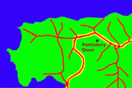
There are hundreds of short ridgeways all over Britain which follow the hill ridges (the watershed) because this is where the ground is most likely to be dry. Sometimes these are linked into long chains which became important routes for early travel. It is thought that the only continuous ridgeway from England to the south west ran across Somerset and north Devon, roughly parallel to the coast, turning south at Berry Cross towards Barnstaple (lower left) and on to Cornwall (4).
The ridgeways in north Devon are usually thought to date from the Bronze or Iron Ages because so few earlier sites are known, but if the only main route to the south-west did indeed run through north Devon, then it was almost certainly used during the Neolithic period, or even earlier. It is tempting to imagine that, over 4,000 years ago, Kentisbury Down was the equivalent of a present-day motorway services on the Great West Way.
(1) Chambered tombs
"On Morte Point, just at brow, may be seen what is supposed to be a Druidical monument or altar consisting of a large stone resting on two others." (Wilson 1976 p 84)
"No long barrows have so far been located in north Devon....two sites, between Morte Point [SS 45304550, first claimed as cromlech by Rev G Tugwell 1877 p56 [‘On Morte Point, just at the brow of the decavity, half concealed by briars, is a so-called cromlech, and ancient Druidical monument, consisting of a rude slab placed on two perpendicular ones’] and Woolacombe [SS 45974446, shown on earlier OS maps as a burial chamber, now removed], formerly considered burial chambers, are now believed to be natural groupings of stones" (Grinsell 1970 p 97, quotes in square brackets from his appendix of sites & finds)
(2) Possible Henge monument, Parracombe Common
On a north-east spur of Parracombe Common, near the head of a tributary of the West Lyn, about a mile north of Chapman Barrows, is a camp that was inspected by Grinsell & Wybrow on 22nd May 1961 and was found to be roughly circular, with bank outside ditch, 47 paces diameter, possibly a henge or disc barrow. From examples excavated these are of late Neolithic. (Grinsell 1970 p25) Parracombe Common, SS 69184489, 47 paces diameter, 1’ high, Scheduled Ancient Monument, probably a disc-barrow with only slight traces of central mound. Bank and inner ditch each about 13 ½ ’ wide; 1’ from bottom of ditch to top of bank. (Grinsell 1970 from list of North Devon barrows p 127)
"The other evidence of Neolithic occupation on Exmoor is a superficially unimpressive earthwork on Parracombe Common, about half-a-mile south-west of Woolhanger [ss691449]. It consists of a circular earth bank about 120 feet in diameter, with a ditch on the inside, which makes it clear that this is not a fortification. It is probably a henge monument of the Neolithic period, a centre for ceremony or worship, and although unique on Exmoor, it is similar to henges in other parts of southern Britain, including Mendip and Cornwall." (Whybrow 1970 p 10-11)
This is marked on the modern Ordnance Survey Landranger maps as a henge but in appendix 1 of Riley & Wilson-North 2001 p 179 a Hut Circle is given at SS693449
(3) Neolithic occupation sites
"The Neolithic succeeded the much longer Mesolithic period around 3000 BC....No Neolithic habitations are known for certain on Exmoor...There are however two Exmoor sites...which indicate that the Neolithic people inhabited and did not merely visit the area. [Kentisbury Down, Parracombe Common] (Whybrow 1970 p 10)
Kentisbury Down
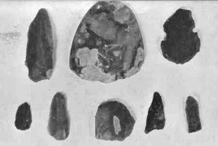
"Between 1966-9 the Rev Henry Ayre, Rector of Kentisbury, picked up on newly ploughed land on the north slopes of Kentisbury Down [SS 631439] more than 600 flint flakes, cores and artefacts which range in date from early Neolithic to the Beaker Period. Their main concentration was in an area of not more than two or three acres but a number of outlying specimens were found within a quarter of a mile. In the same field is what appears to be a lynchet with a possible roadway cutting downwards through it. No positive evidence of habitation was noticed, but the numerous flints do indicate a long-occupied site. The artefacts consist mostly of varieties of scrapers, including several of the waisted type. There are a number of arrowheads, both leaf-shaped and tanged-and-barbed. An unusual find was a polished discoidal knife (a round, flat cutting implement) which is a rarity in South-West England, although another was found many years ago on Furzehill Common. All the flints have been deposited in the North Devon Athenaeum at Barnstaple." (Whybrow 1970 p 10-11) The picture of flints above is taken from p 18 (the flints are in the North Devon Museum, Barnstaple).
At Kentisbury Down, the polished-edge flint knife dates from late Neolithic but the discoidal knife may be late Neolithic/Beaker from 2000-1500 BC (Grinsell 1970 p 23)
"Between 1966 and 1968 the Reverend W G Eyre, Rector of Kentisbury, collected more than 600 worked flints from a field on Kentisbury Down, which had recently been ploughed for the first time. Some microliths were found, together with Neolithic and Early Bronze Age arrow-heads. A prehistoric enclosure of the 1st Millennium BC lies close by, highlighting the evidence for human activity of Exmoor through many millennia." (Riley & Wilson-North 2001 p 17)
Lundy
There are 3 areas of prehistoric settlement on Lundy. The first, around Brick Field, was investigated by Dr ATJ Dollar in 1932, who collected more than 500 flint flakes. Several large upright stones in this area were thought to be menhirs. The second site, just north of ¾ wall in 1954 yielded a considerable number of fragments of flint and chert. The 3rd site on the plateau north of Gannets Combe was exposed by fire in 1934 and consists of a series of walled enclosures with the remains of at least 8 hut circles. A tumulus on Tibbets Hill was opened by Loyd in 1922 who found a cist within. These sites are thought to date from Neolithic or early Bronze Age. (Langham 1960 p 5-6)
(4) Ridgeways
There is doubt over the main route of communication west through Devon and Cornwall in prehistoric times. Ridgeways followed the watershed which in Devon are convoluted but there is no doubt that the Great Somerset Ridgeway continued to the west. (Grundy 1941-2 p133) One possible route is south-east to near Dulverton, then south-west to near Crediton, crossing Dartmoor to Okehampton. This is problematic across Dartmoor, where there appear to be no paths extant. To north-east Cornwall the route takes 90 miles to cover 32 miles, a tortuous route. The only other route, west to Kentisbury and south-west to Barnstaple and beyond, is some 40 miles less. "On the whole it looks as if this road ought to be definitely accepted as the Devon section of the great road to the west." (Grundy 1941-2 p 135-143)
The various ridgeways are the attenuated survivals of what they were before the enclosure acts of C18th, when they would have been wider and often in the form of parallel tracks (corduroy tracks), a fresh one forming when the last became unusable. Those in our region are likely to be Bronze Age; they are unlikely to be earlier due to the lack of Neolithic sites. (Grinsell 1970 p 142)